9-18-13. Bogazkale, Turkey
After wedging myself onto Ankara’s badly overcrowded subway (a taste of things to come), I rode to the end of the line at ASTI, the mammoth bus terminal. I needed to reach Sungurlu, the only town of any size near the site of Hattusa, and finally booked a seat on a bus that “passed through” the city. Three hours into a ride over the treeless steppe, the bus pulled to the side of the highway in the middle of a small city. I asked the driver where the otogar was, and he pointed towards a clump of apartment buildings. And then, before I had a chance to question him further, the bus was gone.
I got very lost in the ensuing hour. The station obviously was nowhere near the area the driver had indicated – and so it was time to start asking directions. I have now spent 70 or so days travelling in Turkey, and have gotten lost (in some way or other) on virtually every one of them, usually to the point of needing ask directions. Yet I have never stopped hating it. First, it is a matter of principle. Asking directions is tantamount to admitting defeat: you have tried to find your way, and failed. This bothers some testosterone-laden lobe of my brain. Secondly, there is the issue of language. I know enough Turkish to ask reasonably intelligible questions, but not quite enough to always interpret the answers adquately; often as not, I seem to come away more baffled than before. And finally, I always ask the wrong person.
In Sungurlu, the first man I addressed proved to be stone deaf. I asked him where the otogar was. “WHAT?” When I eventually got through to him, he responded simply: “otogar yok” (there is no bus station). That was hardly encouraging. Next I spotted a pleasant-looking woman standing in her yard with a gaggle of children. Just as I approached to ask, she pointed at something (a rat, I think) scurrying across her yard and starting whipping rocks at it. One of the rocks must have slowed the vermin down; when I left, she was whacking it with a shovel.
Target number three was a pair of boys, probably in seventh or eighth grade, both in school uniform. I put the question to them. One called excitedly to another uniformed boy a little down the street: “hey Hassan! This German wants to know where the otogar is!” Hassan was, presumably, taking German; at any rate, he didn’t know English. His German, as it turned out, wasn’t great either, so I mentioned that I knew a little Turkish. This triggered a thoroughly incomprehensible set of directions, delivered with gesticulations to the left, right, and (worryingly) up. I asked him to go through it a little slower. In the meantime, literally thirty children (apparently all from the same school) had formed a circle around me and my interlocutor. Most were shouting contradictory advice to Hassan: “tell him to go right at…” “no, have him go left at…” “isn’t it just straight ahead?” Etc. I, of course, couldn’t hear anything over all the shouting, but gathered from the general consensus that there were at least two different bus stations, at least one of them was across the highway, and neither was anywhere near this neighborhood. I thanked the mob (they will probably be taking about the “German” for weeks), and started along what I hoped was the right road. After a few minutes, I hear the patter of feet and saw Hassan (together with one of his cronies) come jogging up. “So…” he said “money?” Mercenary little wretch. The fourth person I asked for directions, an elderly shopkeeper, was somewhat more helpful, and pointed me across the highway. The fifth, a parking attendant, finally sent me down the right street; and the sixth proved to be the driver of the dolmus to Bogazkale, the village near Hattusa.
I asked when the dolmus would leave. “When it is full.” Having ridden in many a dolmus, I knew what that meant – by the time the 9-seat van finally left, it held no less than 17 people, all (besides myself) elderly locals. I was crushed into the back bench with three malodorous old men. When the van stopped near the access road to Hattusa, I scrambled out with great relief (there was no AC) – and discovered that my destination lay two miles uphill.
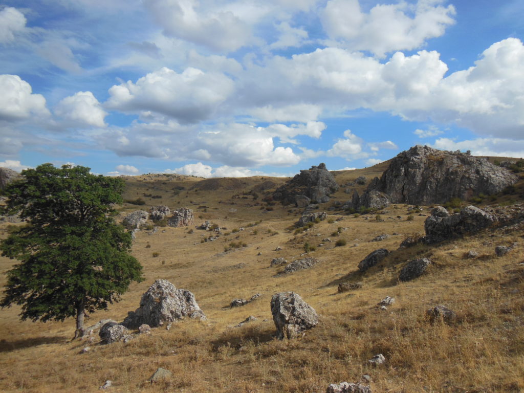
Normally, this would have been no problem; the weather was fine and the scenery beautiful. But time was at a premium, and so I ran most of the way up. Most of the way, because I didn’t want to totally exhaust myself before reaching my goal: Hattusa, capital of the Hittites. For about three centuries (15th– 12th cent. BC), this was one of the largest and most important cities on earth, seat of an empire stretching from the Aegean to Assyria. Some of the greatest Hittite kings fought the mighty pharaohs of the eighteenth dynasty to a standstill in Syria; but their capital was sacked in the chaos that ended the Bronze Age, and soon fell into insignificance. By the time the first Romans set foot in Asia Minor, a thousand years of grass covered the ashes of Hattusa. Only in the nineteenth century were the ruins rediscovered.

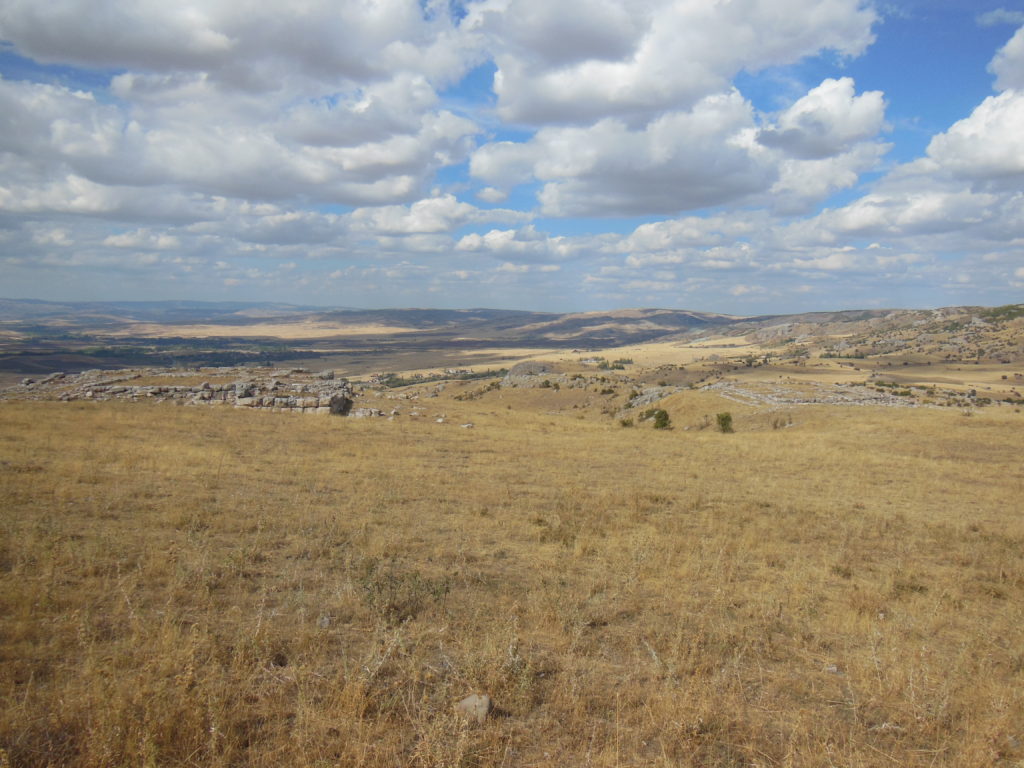
Excavations, conducted intermittently over the past century and a half, have uncovered many of the public buildings. Most of the area within the walls, however, remains unexcavated, largely on account of the site’s vast size. The outer wall circuit is nearly five miles in length. Within – to judge from the extant ruins – building was nucleated. From a practical standpoint, this lack of a single monumental center means a lot of walking. Fortunately, there was plenty to keep my attention off my aching feet. The ruins were set against a backdrop of endless hills, brown summits rolling to meet the cumulus clouds which traced the horizon. Besides the town of Bogazkale, crouched between two hills just beneath the site, it was an empty landscape. A cool wind whistled over the bending grass, harshly counterpointed by the slap of my battered soles.
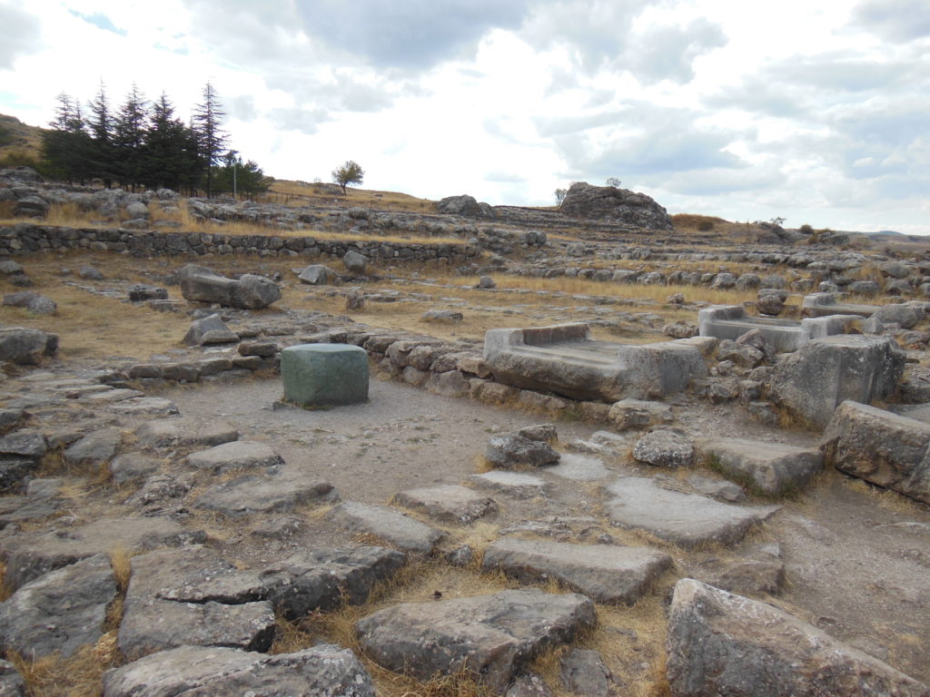
No Hittite building was well-preserved – only a few city gates stood to near their original height – but enough remained for imagination to do its work. Nowhere was this more evident than in the first temple complex I encountered, the rather unimaginatively named Buyuk Mabet (great temple). Dedicated to two of the more important deities in the Hittites’ thousand-god pantheon, the complex consists of many small storerooms ringing a large central chamber. The chamber seems to have been used for propitiatory rituals (the actual idols were secreted from profane eyes in niches behind), as was the main room of the priests’ house opposite, where a square green stone, polished or worn smooth, is thought to have played an important part in the state religion. No wall stands higher than five or six feet; but there is a real sense of ancient grandeur in this place. I could imagine the Hittite king, resplendent in his pronged crown, leading a cadre of bearded priests through the great gate, hoping, perhaps, that the great god Teshub would grant him victory over the armies of the insolent pharaoh.
Climbing a few hundred yards in the shadow of the ancient curtain wall, I came to the great citadel, the place from which the Hittite kings dominated Anatolia. Though the foundations of one or two palace structures are discernible, most of the excavated remains have been reburied for the sake of preservation, leaving relatively little to see. I did, however, get a good picture of the rolling landscape, framed by a complacent cow.

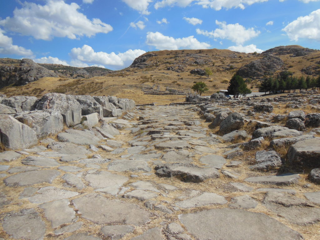
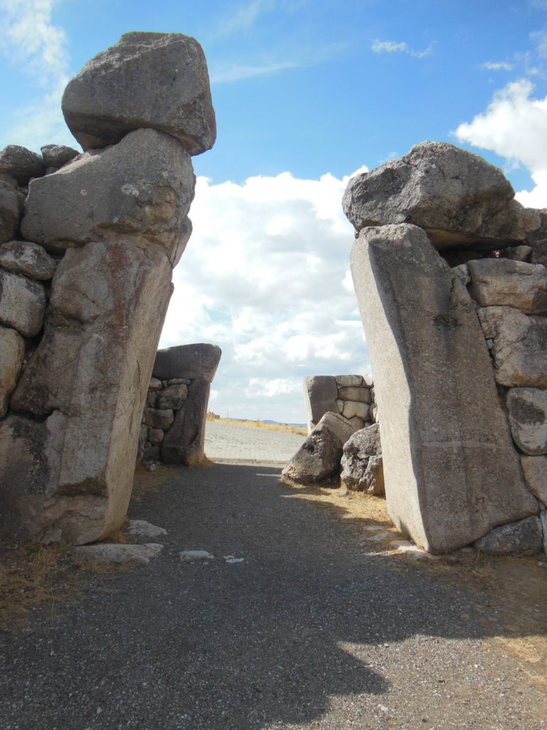
The same view was set off by the well-preserved King’s Gate, located a few hundred yards beyond the palace. Preserved nearly to their full height of twenty feet, two pairs of monoliths (the ancient gate posts) rise from the squat rubble of the surrounding walls. On the inner face is carved the relief from the gate was named, a life-sized royal figure with almond-shaped eyes. Less spectacular but equally impressive is the nearby hieroglyph chamber, a small cave inscribed with the deeds of Supiluliuma II, last of the Hittite kings. A badly-weathered inscription on the outcropping opposite seems to have carved around the same time. I paused here to think about the sheer amount of time this weathering bespoke.
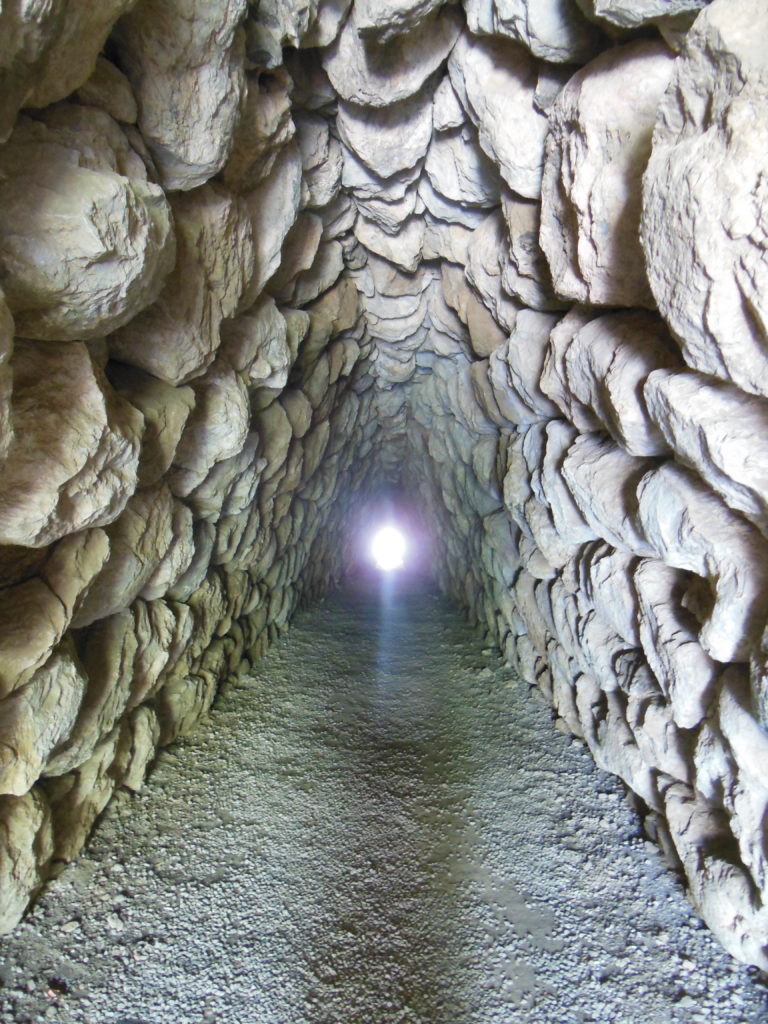
The next major monument was the so-called Yer Kapi (tunnel gate). As its name suggests, this is a subterranean passage driven through the great artificial hill which served as Hattusa’s northern bulwark. Nearly 80 meters long, it is thought to have served a ritual, rather than defensive, purpose.
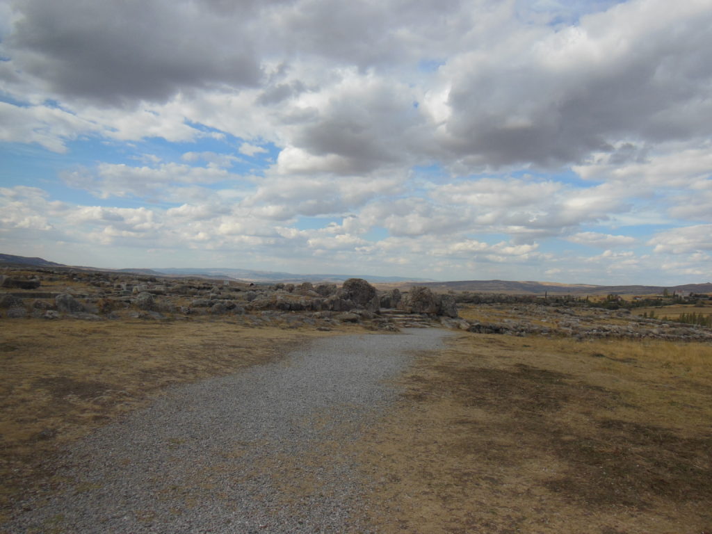
Once I emerged blinking from the corbelled tunnel, I took a moment to survey the upper city, whose ruins were spread over a long grass-covered slope. From where I stood, I could see two or three dozen square enclosures, all the foundations of temples. One ruin, perched atop a rocky spur in the middle of this panorama, was particularly picturesque. Perhaps it was dedicated to a god of wind or weather.
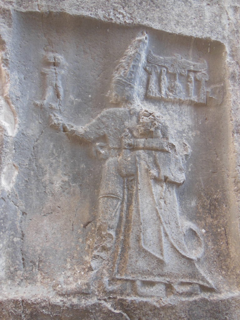
Alone beneath a vast sky of broken clouds, I walked the last mile back to the ticket booth. One sight, two miles away, still lay before me; and I only had an hour before the last bus. So I jogged. The discomfort was broken by a bit of comic relief when a Kangal puppy came yipping out of a farmyard to nip at my heels; but I was dripping with sweat by the time I drew near to Yazilikaya.
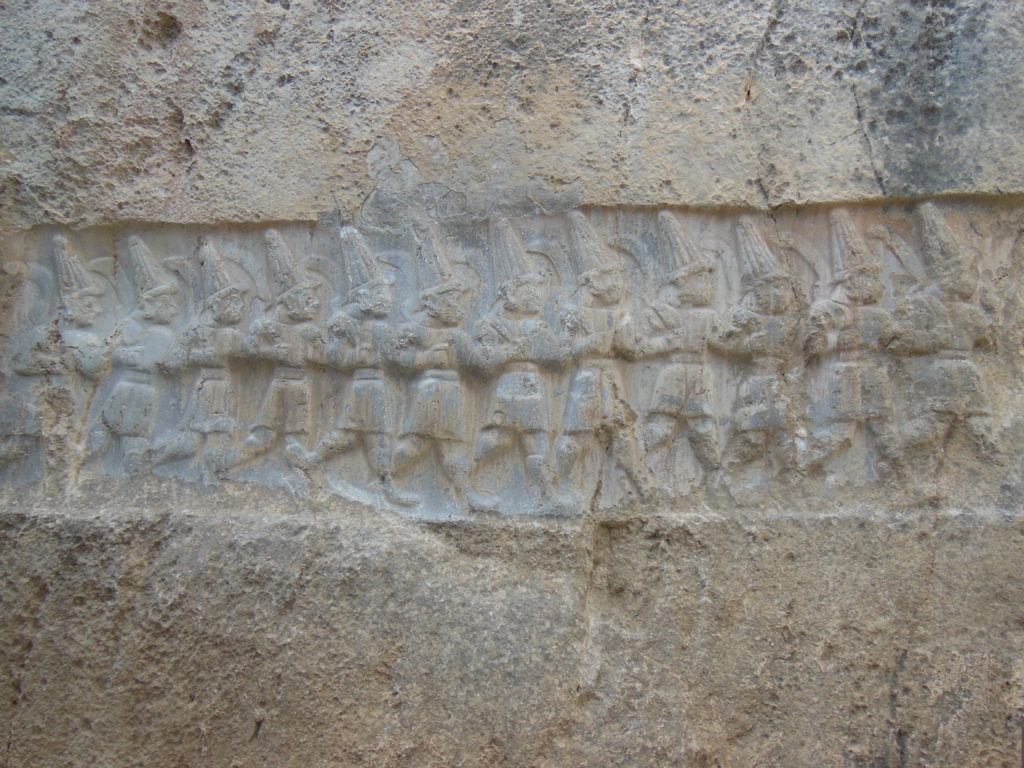
Thought to have been one of the most important Hittite sanctuaries, this fissured mass of rock is famous for its reliefs. There are two chambers. The walls of one, probably the site of a New Year’s ritual, bear depictions of the greater Hittite gods in procession, joined (naturally enough) by the king who commissioned the work. The other is thought to have served as a sort of funerary chapel for Tudhaliya IV, father of Supiluliuma I, greatest of the Hittite kings. Beside a file of sword-bearing underworld gods is carved a stylized figure of Nergal, lord of death. Lion-headed griffins guard the way to the land of the living.
Blog Home