10/12 – 10/14/19
10/12
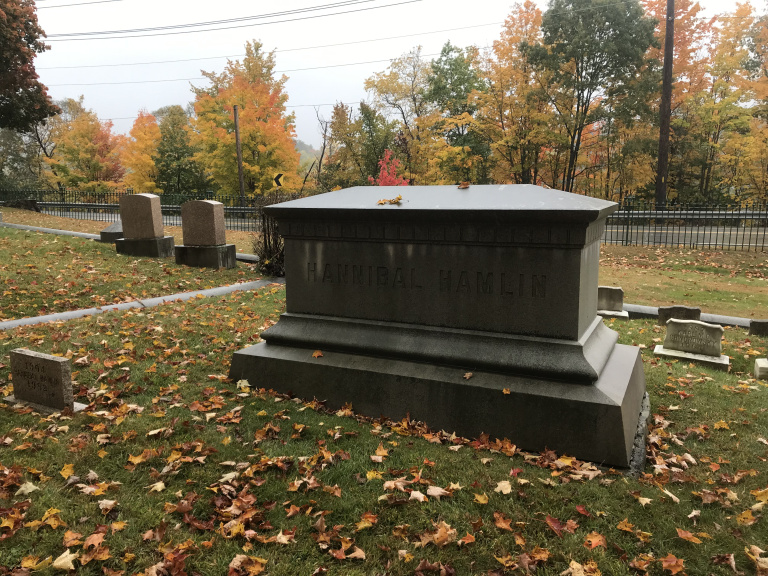
Just before dawn, in a spitting drizzle, I left my windswept campground in Houlton, Maine and headed south, squinting appreciatively through spattered windows at the fall color along the road. I stopped in Bangor to indulge my old passion for the graves of obscure figures from American history. Somehow or other, I had discovered that Hannibal Hamlin, Lincoln’s first vice president, was buried in Bangor’s Mount Hope Cemetery. So thither I went. After a great deal of maneuvering (and after nearly colliding head-on with a Stephen King tour bus), I finally discovered the tomb. Worth it.
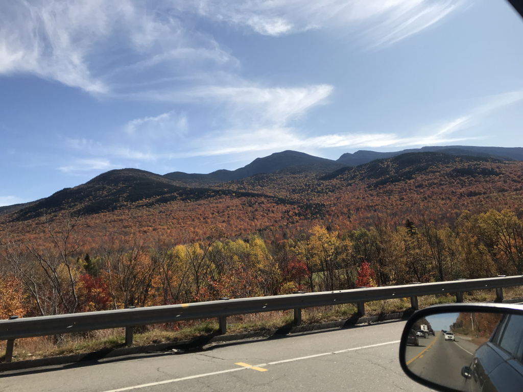
I lunched on a gargantuan lobster roll at a restaurant on the banks of the Penobscot River. Then I continued westward along US-2, a two-lane road rolling through faded towns, harvested fields, and long stretches of maple forest. As I approached the New Hampshire border, the landscape became increasingly hilly, and the cloud-hung summits of the White Mountains filled the western horizon.
At Bethel, eastern gateway of the White Mountains, the Leaf People appeared – RVers with silver hair, New York plates, and a powerful urge to congregate around every handy maple grove. Irritating though I found the sudden crowds, I had to admit that the landscape was stunning – hills and mountains blanketed, from foot to cloud, with blazing maples.
Following a narrow side road beside a leaf-spangled brook, I drove to the trailhead for Caribou Mountain, which was (I had read) one of the most scenic hikes in Maine. Unfortunately, the top half of the mountain was blanketed by the low clouds that had hung overhead all day, and I spent most of the hike blundering through dense mist. There is something special about a misty forest in fall, when water droplets tremble at the tips of gilded leaves – but this did not outweigh my disappointment at being able to see only fog from the summit.
Returning to the parking lot near sunset, I headed west past the feet of the White Mountains, pausing for a picture of distant Mount Washington. Then I continued to the picturesque (or so I assume; it was dark) town of Whitefield, where I ate a surprisingly quaint gas station / subway. My room, in what the Airbnb ad generously called a “hostel,” was 4 x 8 feet, windowless, and clearly a former pantry. It did, however, have a dish of maple syrup candies. As I sat on my bed typing this journal, the host’s cat suddenly wriggled through the folding screen that served as my door and leapt onto the bed. Over the next half-hour, she managed to knock my laptop over, shower my open suitcase with hair, and repeatedly get her claws stuck in the comforter. Then, as abruptly as she had come, she slipped back through the screen.
10/13
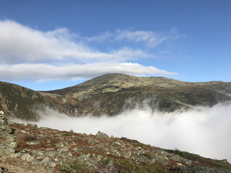
I left Whitefield about an hour before dawn. I had decided to hike up Mount Washington; and since it was the Sunday of Columbus Day weekend, I wanted to get an early start. Parking in the pre-dawn twilight, I took a long look up at the summit, half-hidden by cloud. Then I laced my boots, and started up. Since a steady stream of hikers was already funneling up the main (Tuckerman Ravine) trail, I decided to take the Boott Spur – a narrow and lightly-trafficked alternative route.
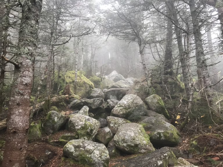
The trail was rugged, and often involved scrambling up boulder piles. Within a half-hour, in a reprise of the previous day’s hike, I climbed into thick fog. For what felt like a long time, I clambered steadily upward, plowing through an absurd number of cobwebs and shivering in the clammy chill. Then, suddenly, I broke through the mist.
It was a magical moment. A few feet behind, a wall of fog stirred uneasily, like some nocturnal beast surprised by day. Ahead rose a steep slope of dwarf pines, sparkling in the sudden sunshine. A short distance up the trail, I was treated to my first clear view of the summit- a magnificent pyramid, ringed by swirling cloud.
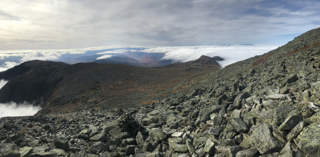
I continued along a barren ridge washed by streamers of cloud. After a hard climb up a windswept slope, I emerged on a shoulder of the mountain. The clouds to the north had finally begun to clear, revealing a spectacular panorama of crimson hills.
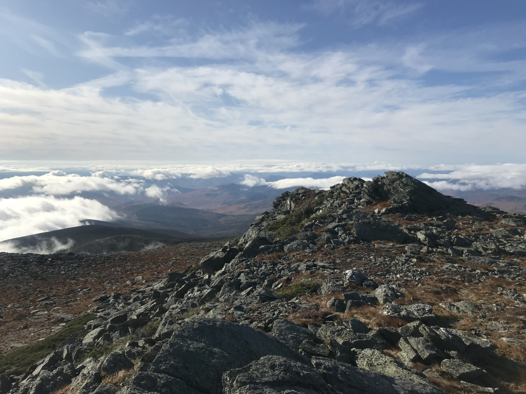
After stopping to savor the view (and the fact that there were no other hikers in sight), I picked my way across a plain of broken granite and re-joined the main path. The last half-mile consisted of a relentless series of switchbacks up loose and shifting rocks. Then, at last I reached the summit – and found a tourist circus.
The summit of Mount Washington is accessible by both auto road and cog railway; and both were operating at full capacity on this holiday weekend, disgorging crowds of visitors. Although I knew that the road and parking lots would be there, it was still something of a shock to actually see them. Like old Quebec, the summit had a bad case of TMFT; so I more or less immediately started back down the mountain, this time following the main trail.
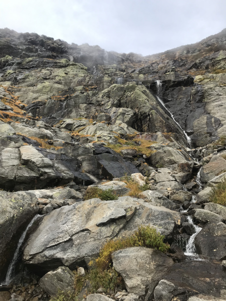
As usual, down was harder than up. My hiking sticks helped; but it was tough and slow going, not least because dozens of hikers were still coming up the trail. Parts of the trail were surprisingly beautiful – I especially liked a slender waterfall that cascaded 200 feet to a pool beside the middle section. Most were just hard work.
By the time I returned to my car, the clouds had dissipated. The weather, in fact, was just about perfect for October: in the high fifties, with a light breeze that gently drifted fallen leaves. I encountered some difficulties leaving the area – the volume of cars entering the Mount Washington road had caused a three-mile traffic jam – but soon I was back on the highway. As I left the White Mountains, I opened my window for a final picture of the foothills of Mount Washington, cloaked in scarlet maples.
Again following US-2, I continued into Vermont, passing small towns, russet woods, and what must be an unsustainable number of antique shops. I stopped at a roadside outside Montpelier, ordered the special (a turkey dinner) and eavesdropped on the elderly ladies at the table across from mine. The sun set as I neared Burlington, and a great golden moon hovered over Lake Champlain as I crossed into New York. That moon, bright enough to make the road shine faintly, lit my way to the town of Massena, where I had booked a room.
10/14
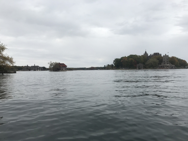
Paralleling the Saint Lawrence River, I drove through a level landscape of golden birches and rustling corn. Here and there, dawn light filtered through a broken overcast. I was headed toward the famous Thousand Islands, the miniature archipelago that spangles the Saint Lawrence River just downstream from its mouth on Lake Ontario. Around the turn of the twentieth century, the Thousand Islands were a favorite summer destination for the New York gentry, who built sprawling mansions on some of the grander islands. Though less fashionable these days, it remains a popular vacation spot (as I was to discover).
I had decided to kayak a ten-mile stretch of the Saint Lawrence through the heart of the Thousand Islands. Per my usual method, I first locked my bike at the place I planned to land. Then I drove to the launch point near Alexandria, put my phone and car key in their waterproof bags, and launched into the cold, sea-green river.
The weather was cool, cloudy, and windy, with a spitting drizzle that periodically intensified into a steady rain. When not bobbing over wakes or spinning in hidden eddies, I admired the mansions on both sides of the channel, many already shuttered for the winter. As I crossed to the other shore, I had an uncomfortably close encounter with a large tour boat, which emerged suddenly from between two islands. These boats, I soon discovered, were everywhere – it was the last big weekend of the season, and hundreds of visitors on both sides of the border had apparently decided to ride out the bad weather by taking tours.
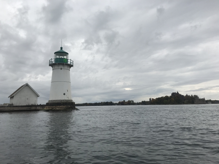
After craning my neck to check for boats (the patter of the rain made it difficult to hear them until they were dangerously close), I sprinted (or whatever the kayaking equivalent of that is) across a channel for a close look at Boldt Castle, the most spectacular of the Thousand Islands’ Gilded Age mansions.
Another frantic channel crossing brought me to a diminutive lighthouse in the middle of the river, which hosted an immense flock of seagulls. As these exploded into panicked flight at my approach, I followed suit, and finally managed to reach the south shore of the river, far from the tour boat route.
Almost immediately, however, I encountered a new problem. The north wind that had been pushing me all morning had grown stronger; and since the section of river I was paddling was nearly a mile wide, a stiff two-foot chop sprang up in exactly the wrong direction, making my kayak wobble like a wounded manatee. I was pretty worn down by the time I reached the take-out point, but I had no choice but to hop on my bike and pedal the ten miles – all, of course, directly in the teeth of that howling wind – back to my car.
By the time I stowed the bike, returned to the kayak, packed it away, and returned to the highway, it was mid-afternoon. The rest of the day was spent driving across upstate New York, with a brief pause in Rochester for a garbage plate (a spectacular blend of cheeseburger, baked potato, beans, and other savory things). When I finally reached Niagara Falls, I managed to drive to the wrong Econo Lodge (a desperate-looking place in an industrial wasteland) before being directed to the right one (a somewhat less desperate-looking place in a postindustrial wasteland).