10/1 – 10/4/19
The Great Lakes deserve their adjective. They are, first and foremost, really big, containing almost a quarter of the world’s surface fresh water. They dominate the climate and economy of vast parts of North America. And they define, as they have for centuries, the heartlands of two great nations.
I grew up, and currently live, a short drive from the southwest tip of Lake Michigan. Over the years, I have hiked, biked, and listlessly driven around other corners of the Great Lakes. But I was a stranger to most of the Great Lakes basin, simply because the region is so large, and my car so old. And so, feeling one of my periodic bouts of restlessness, I decided to drive around the lakes.
Even by my standards, the itinerary was ambitious. Starting from my parents’ house in south suburban Chicago, I would head north to the Upper Peninsula of Michigan, circle Lake Superior, skirt the Canadian edge of the Great Lakes all the way to the mouth of the Saint Lawrence River, and then return home on the American side.
10/1
The night air was unseasonably warm and steamy. Sweat beaded on my forehead as I jammed the last garbage bags into the trunk of my rental car; and no amount of fiddling with the strange buttons and knobs on the dashboard could banish the fog from my rental car’s windshield. No matter. Dawn was about an hour away. It was time to go.
Once I finally figured out the defrost settings, my drive through Chicagoland went smoothly. North of Milwaukee, however, torrential rain set in, and persisted for nearly three hours. Mid-deluge, I stopped in Green Bay for a splendidly unwholesome burger at a green-and-gold themed joint across the street from Lambeau Field.
North of Green Bay, I paused in the little town of Peshtigo, the site of the deadliest wildfire in American history. A surprisingly large museum, housed in a former church, commemorates the disaster. Since I was the only visitor, I received an extremely thorough tour from the two elderly curators, who showed me melted coins and carbonized canned goods that bore witness to the unimaginable heat of the fire.
The road dwindled to two lanes as I crossed into the Upper Peninsula of Michigan, and Lake Michigan appeared beside the road, choppy and colorless. Although the drizzle stopped, the clouds persisted, and temperature dropped steadily through the forties.
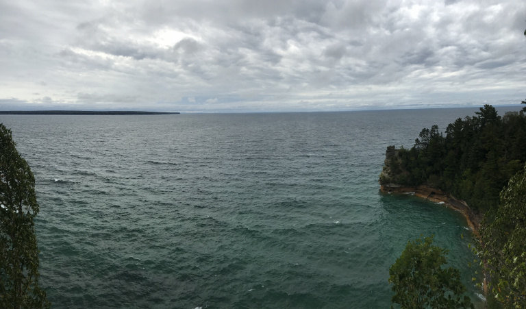
Driving to the western end of Pictured Rocks National Lakeshore, I parked and walked out to a viewing platform over Lake Superior. The lake was steely gray beneath a low overcast. Huge waves, driven by a gusty north wind, thundered into the sandstone cliffs beneath the overlook, sending up geysers of spray. I watched, shivered, and silently promised myself to never bring my inflatable kayak on Lake Superior.
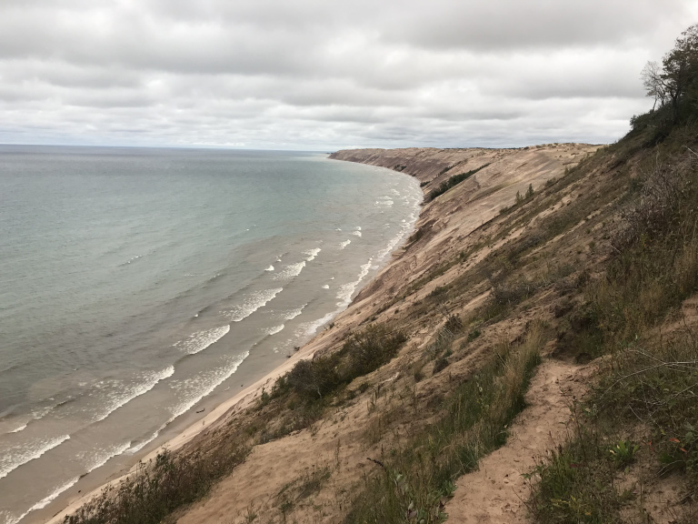
After a long drive to the eastern edge of the park, I took a short steep hike on the crest of the Grand Sable Dunes, a series of 400-foot sand hills sloping steeply to the lake. The wind was howling along the dune tops, flattening the grass and whipping streamers of sand over the path. Far below, waves clawed at a narrow beach.
My campground was a few miles away. After pitching my tent in the shelter of a pine grove, I used the last few minutes of daylight to take a walk on the adjacent beach, stooping occasionally to pick up a pebble that looked a little like an agate if I squinted. A few yards away, eight-foot swells crashed into the beach with a roar I felt in my fillings.
10/2
My tent was down before the sun was up, and dawn caught me on the road to Pictured Rocks’ most famous hike: the 11-mile Chapel Loop. It took a while to reach the trailhead – the access track was more pothole than road – but once I did, I performed the familiar ritual of changing into my hiking boots and filling my water bottles. Then I was off on the first real hike of the trip.
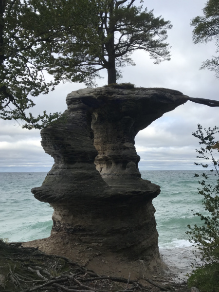
The highlight of the first few miles was Chapel Falls, a 70-foot cataract darkened by flood runoff. As I continued down the trail, drinking in the familiar pine-scented air of the Northwoods, the thunder of the lake grew steadily louder. Then, abruptly, I emerged on the shore beside Chapel Rock, an eroded pinnacle of sandstone topped by what must be a very anxious pine tree.
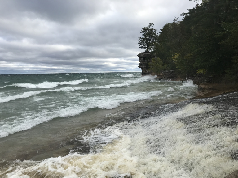
Standing on the shore just beneath Chapel Rock, I had one of those exhilarating moments that make long hikes worthwhile. Beside me, the Chapel River rushed into the lake; above, birches whistled in the wind. And all around, walls of pale green water slammed into the shoreline, throwing up sheets of spray. There was something splendidly elemental about the scene. Coat flapping and eyes closed, I stood there for what felt like a long time, feeling the percussion of the waves on the rocks, tasting spray in the air.
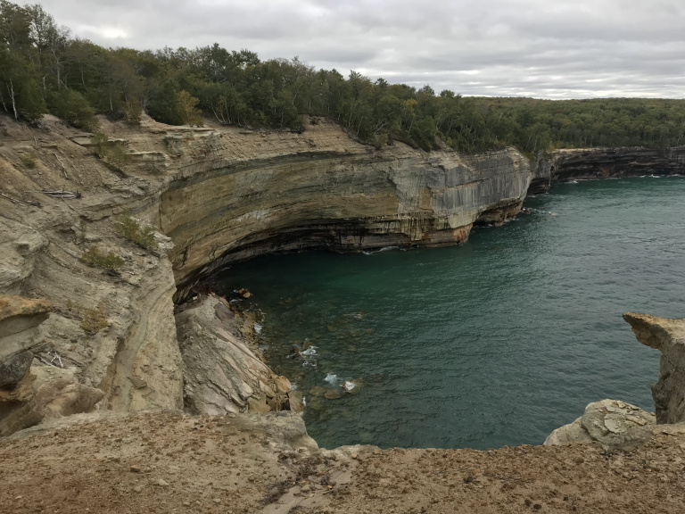
Then I walked slowly down the adjacent beach, pausing for an occasional bleary picture of wave-lashed cliffs. As I returned to the trail at the far end of the beach, the sun finally appeared, streaking the lake with color – turquoise where touched by light, cobalt between. Even the foam on the whitecaps glistened.
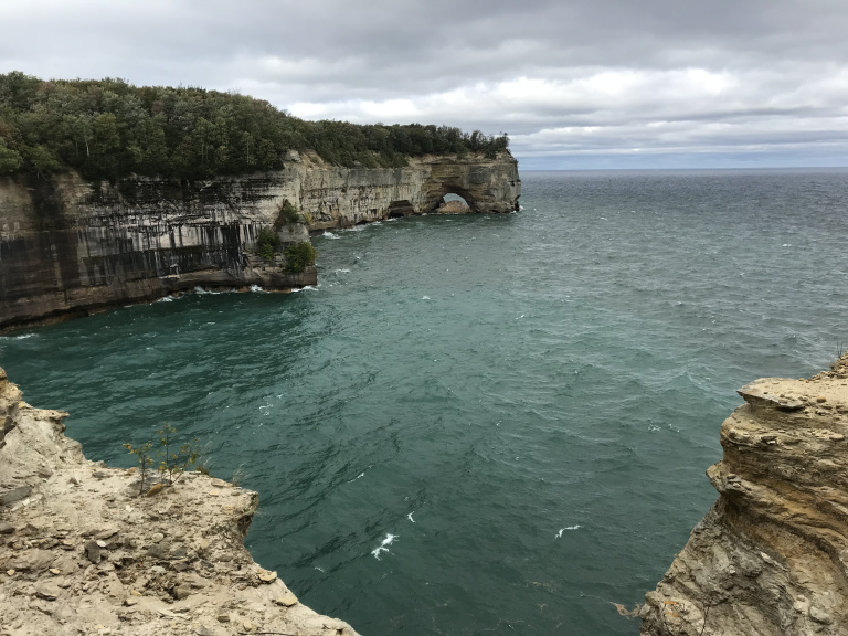
For the next five miles, I hiked atop the lakeshore cliffs. The wind howled and whistled among the trees. A hundred feet below, waves exploded into sea caves with eardrum-throbbing thuds. Every overlook revealed new arches and caves and marching cliffs.
After rattling back down the access road and filling my rental car’s perpetually thirsty tank, I set out on the long drive westward. As I approached the Porcupine Mountains, clouds lowered and darkened behind the crimson maples along the road. A steady rain set in within a few minutes of my arrival in the campground. Donning my raingear, I set up my tent and cooked dinner in a downpour. Then I retreated to my car, where I read by lantern light as rain tapped on the windshield.
10/3
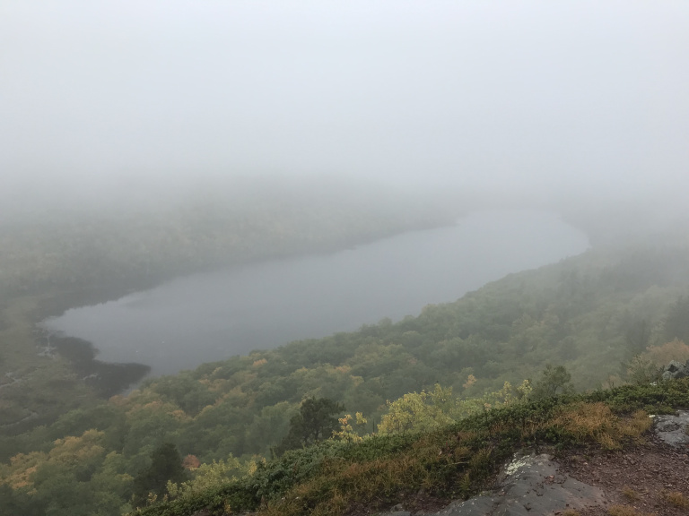
The rain continued all night, with temperatures hovering in the mid-thirties. It could have been worse: in northern Minnesota (as I later learned from the radio), the same storm laid down several inches of snow. After shoving my soaked and muddy tent into two garbage bags, I drove through rain and mist to the Lake of the Clouds.
The Lake, unfortunately, lived up to its name. Waves of fog rolled over the surface, shrouding the opposite shore and allowing only tantalizing glances of the color-soaked woods below.
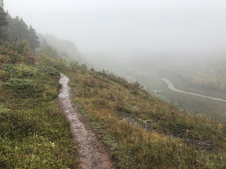
For an hour or so, as the curtains of mist stirred and pulled, parted and reappeared, I hiked along an exposed ridge high above the lake. Isolated by swirling fog and pattering drizzle, I sloshed to a point beyond the far end of the lake, where a wilderness stream snaked off into the mist. And then, feeling water seeping into my boots, I sloshed back to the parking lot.
Although the rain finally stopped as I continued westward through Wisconsin, the heavy clouds persisted, dragged across the sky by a chilly wind. After pausing to gawk at some abandoned ore docks (the colossal concrete structures used to load iron ore onto lake freighters) on the outskirts of Superior, I stopped for a much-needed burger at a nearby tavern.
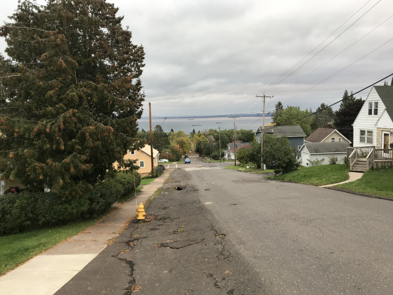
After lunch, I crossed over to Duluth, MN. Parking beside the city’s forlorn-feeling rose garden, I extricated my bike from its cocoon of garbage bags, popped the front wheel back on, and set out to explore. Passing quickly through the modest tourist district (do that many people vacation in Duluth?), I rode down the narrow spit of land that shelters Duluth’s harbor. After doubling back, I watched the vertical lift bridge (the drawbridge over the harbor entrance) open, and took a few pictures of the lighthouse at the end of the harbor jetty.
I continued to an industrial part of the harbor, where massive granaries and warehouses crouched in the shadow of the interstate bridge. Then, after puffing and sweating my way up a road that climbed 600 feet in one miserable mile, I turned onto the Skyline Parkway, a winding two-lane street that runs along the crest of the hills overlooking Duluth. The views were spectacular. Far below, past downtown Duluth and the harbor elevators, a half-dozen freighters speckled the gray surface of the lake. Rain slanted down over the Wisconsin shore.
I headed back downhill by a street so steep that I burned my hands clenching the brakes. As I packed my bike back into the car, the sun made one of its rare appearances, briefly sparking a rainbow over the Wisconsin shore.
10/4
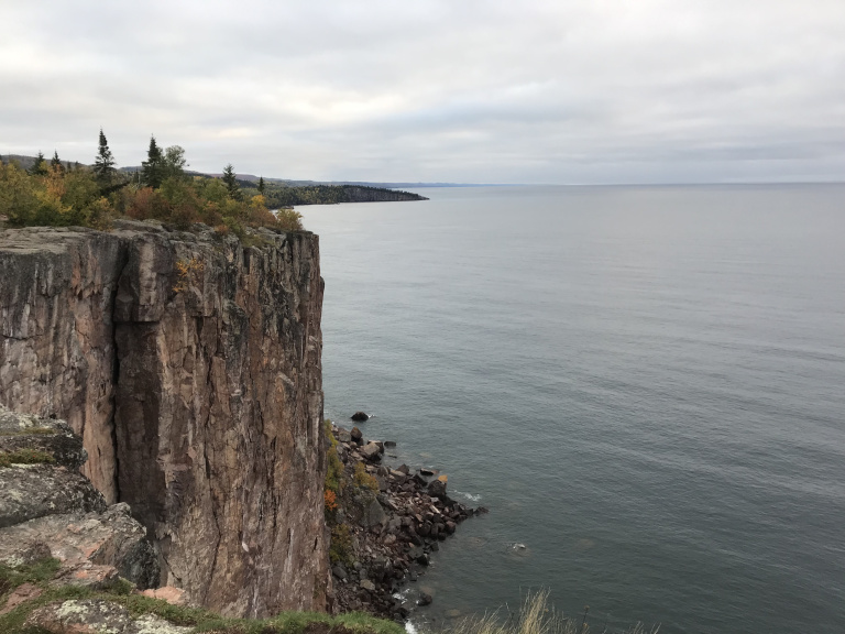
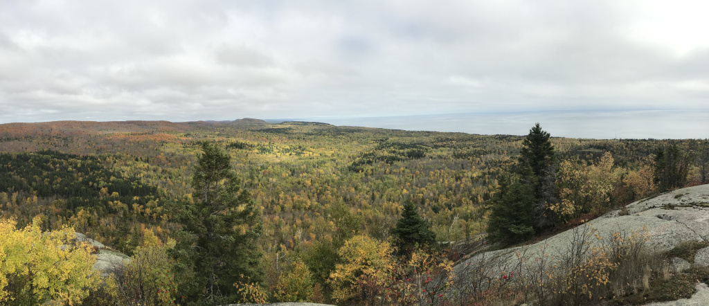
Leaving my frosty campground before dawn, I headed north up Highway 61. My first stop was Palisade Head, a small overlook perched atop a cliff. From here, I could see the landscape that I would exploring the rest of the day: a long range of craggy hills, washed by the silvery lake.
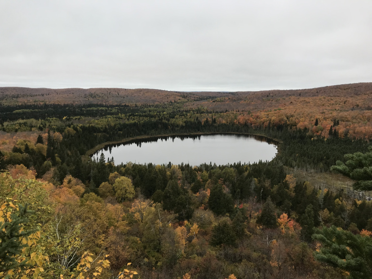
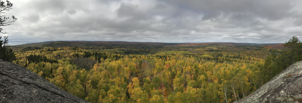
An hour or so later, I hiked into the heart of this view on the Oberg Mountain trail. At first, the experience was underwhelming: the trail was muddy, the sky cloudy, and the temperature in the thirties. But at the first scenic overlook, these inconveniences were forgotten. In every direction, as far as the watering eye could see, stretched a birch and maple forest at the peak of fall color.
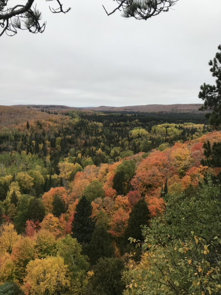
The view from every overlook was more impressive than the last. On one side, the sea of gold and scarlet trees was slashed by the shimmering crescent of the lakeshore; on the other, it rolled over the horizon. I especially liked the section of trail on the northwest side of the mountain, which overlooked a small pond fringed with crimson maples.
As I came down from the trail (which had been almost empty during my hike), I met a steady stream of other hikers coming up. The leaf people had arrived. To avoid the hordes, I made my way to Carlton Peak, a few miles inland and slightly off the beaten track. Before setting off, I draped my sopping tent and tarp over nearby trees, hoping that the cold breeze would dry them. Then, for good measure, I unrolled my damp sleeping bags and spread them out on the roof of my car.
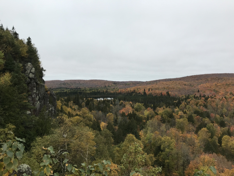
After twisting for a mile or so through a shivering birch forest, the Carlton Peak trail abruptly scaled a steep slope. At the top, I was greeted by another astonishing view of stained-glass forest. Finding a convenient granite ledge, I sat and watched stray beams of sunlight sift through the clouds and play over rustling trees.
Toward the end of the return hike, I felt raindrops on my face. Mind flashing to my exposed tent and sleeping bags, I half-jogged, half-powerwalked the rest of the way, hoping that the pines over the parking lot would ward off most of the water. Finding my gear still reasonably dry, I crammed it into the trunk and back seat as quickly as I could – and almost the instant I finished, a short but soaking drizzle set in.
Driving onward and northward, I stopped for a pleasant half-hour at the Kadence River, a narrow stream that rushes into Superior at a stony beach just off highway 61. After walking up and down the beach and washing my hands in icy lake water, I hiked along the narrow canyon – sometimes only 20 feet wide but 100 or more deep – the Kadence has cut into the granite bedrock.
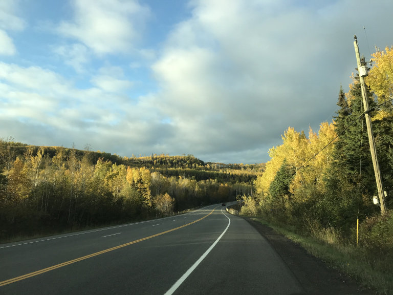
The landscape grew more rugged as I approached the Canadian border. After pausing at Grand Portage to fill my tank (gas on the Canadian side would be almost twice as expensive), I managed to assure the customs agent that I had no firearms in the car, despite my American passport. I was waved through, and into a strange world of kilometers and bilingual signs. The clouds had finally broken; and a few miles north of the border, I pulled onto the shoulder to take a picture of a golden grove of birches, shimmering in the sunset.
Then I continued to the gritty city of Thunder Bay, and the first motel of the trip. Objectively speaking, my motel was pretty grim. The walls were thin and the sheets stained. The view from my window embraced a line of graffiti-spattered train cars and an abandoned grain elevator. A sign on the door to the parking lot reminded guests, with more honesty than tact, to KEEP THE DOOR CLOSED: MICE KEEP GETTING IN. But the room was worth every one of the 37 dollars it cost, for one simple reason: it was not a tent.