10/5 – 10/7/19
10/5
I left my motel well before dawn, steering into a cold wind that rocked my car and sent leaves whipping down the dark road. After about an hour, as daylight revealed a hilly landscape carpeted with golden birches, I turned down a lonely access road to Ouimet Canyon Provincial Park. Parking in the deserted lot, still fringed with snow from the storm three days before, I picked my way along the icy path toward the canyon.
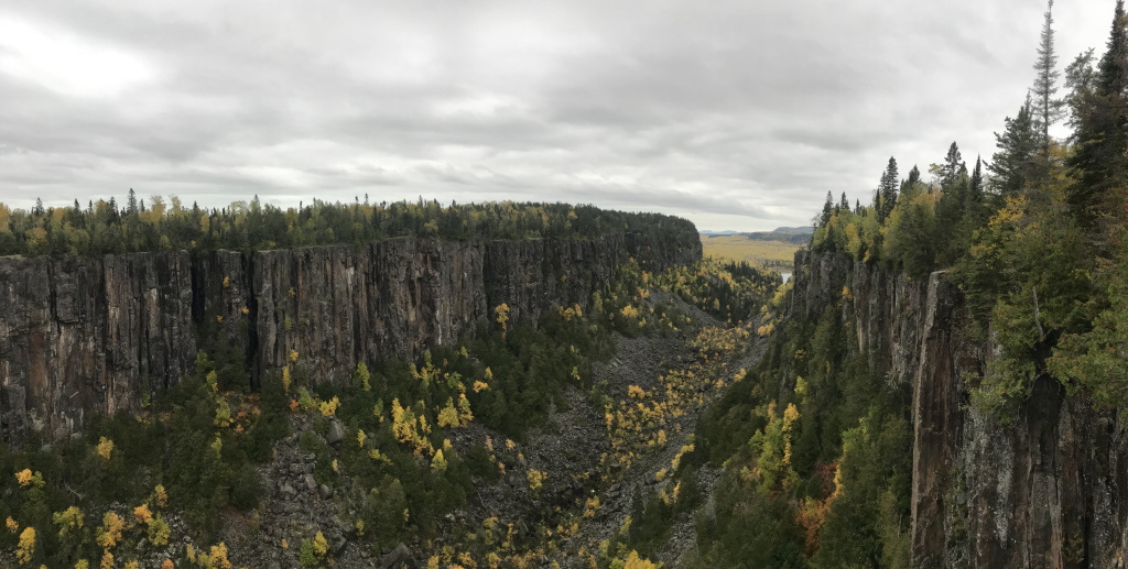
When I finally emerged on the windswept viewing platform, I found myself confronted with an awesomely forbidding landscape. The canyon was a gash in the wilderness, open to a sullen sky. A frigid wind stirred the sea of yellow birches at the canyon mouth. Pines whistled and moaned overhead. Awed but chilled, I took my pictures, scurried over to the other viewing platform, and then beat a hasty retreat to my car.
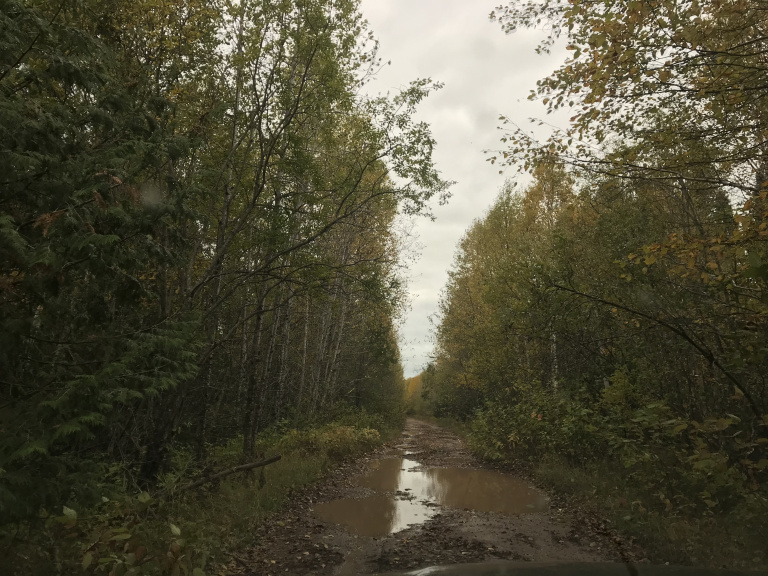
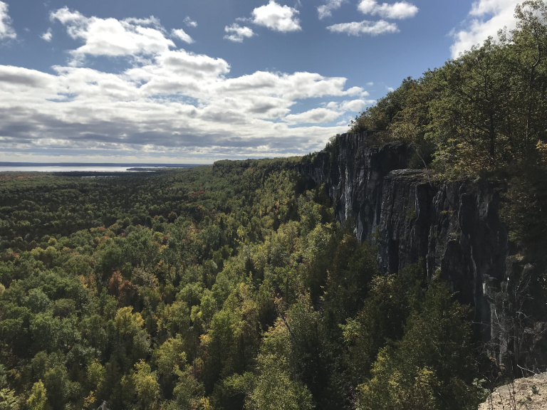
My next stop was Ruby Lake Provincial Park. A long-neglected thread on Canadian Tripadvisor had mentioned a hike to an impressive overlook. As I soon discovered, however, Ruby Lake isn’t really set up for visitors. The only road into the park was unmarked, and (as I realized when it was too late to turn around) designed only for four wheel drive vehicles. Splashing through hub cab-deep puddles and bumping over fallen trees, I finally reached a point at which the road became completely impassable. Having come this far, I parked and continued on foot.
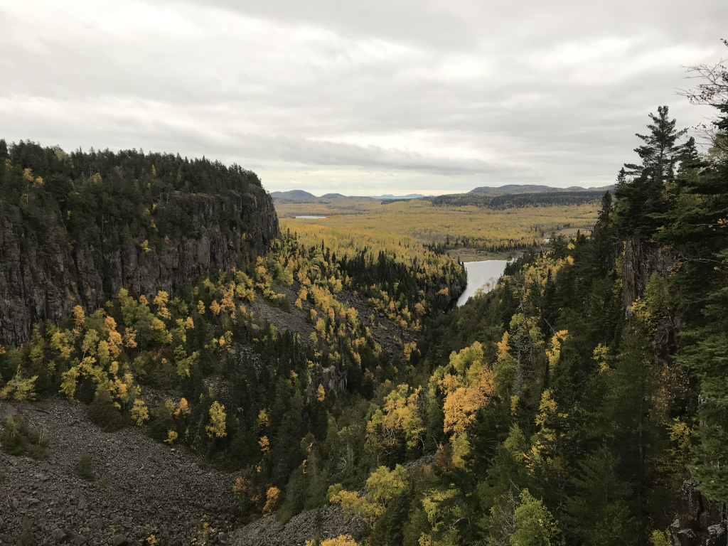
I walked up the track for about two miles. The same wind that had roared down Ouimet Canyon lashed the birches overhead, whipping leaves past my feet. To the west, a darkening sky promised rain. Finally, as the track narrowed again, I saw a faded trail marker on the right, half-hidden by brush. A few minutes down the leaf-covered path, I discovered the elusive overlook.
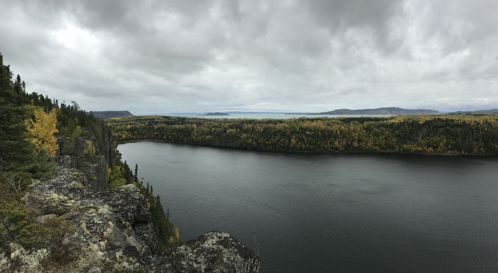
Even for a traveler as jaded as yours truly, the view was breathtaking. Two hundred feet below, waves ridged the surface of narrow Ruby Lake. Tall granite cliffs, crowned with golden birches, ringed the shore. Beyond, filling the western horizon, was the northernmost bay of Lake Superior. Bracing myself against the tree, I took my pictures. But I only lingered for a few minutes. A wall of rain was approaching from the west.
Just as drizzle began to arc through the whistling birches, I dove into the car, forcing half-numb fingers to unlace my hiking boots and slip on my driving sneakers. Then I was off again, breathing a sigh of relief when I managed to reach the highway without blowing out a tire on the access track.
Eventually, the rain stopped. But the heavy overcast persisted, as did the lines of golden birches along the road. Occasionally, a granite outcropping or arm of Lake Superior would break into view. Then the road would bend, and the birches resume. Besides a few brief stops and a quick nap in the town of White River (the birthplace, apparently, of the bear that inspired Winnie-the-Pooh), I drove for the remainder of the day, gradually circling the lake. As I drove, I was impressed by the isolation of the region. In nine hours, I passed only a half-dozen towns worthy of the name. The rest was just trees and lakes. Often, I couldn’t even find a radio station.
Finally, towards evening, the highway reached the eastern shore of Superior, and a region of hills covered with crimson maples. I had planned to camp in Lake Superior Provincial Park – but as I approached the destination, the clouds lowered and darkened, and the wind began to push my car noticeably. Finally finding a radio station, I learned that the evening’s forecast called for heavy rain and winds gusting to 40 Mph. So I decided to push on to Sault Ste. Marie, where I took the last room in a modest but clean motel. After checking in, I set up my propane stove beneath the motel eaves, and cooked dinner there as rain pattered on the parking lot.
10/6
Before leaving Sault Ste. Marie, I drove to the old lock on the Canadian side, now used by recreational craft passing between Lakes Superior and Huron. After taking a few photos of the lock and the international bridge behind, I returned to my car and headed east. For the next three hours, I drove through a landscape more picturesque than dramatic. Birds bobbed in reedy marshes. Gentle hills framed white farmhouses. And in the distance, the North Channel of Lake Huron glimmered in tentative sunlight.
The terrain became more interesting once I crossed the one-lane bridge onto Manitoulin Island. Manitoulin (the world’s largest freshwater island, in case you get your geographical trivia from this blog) is long and narrow, basically a hundred-mile eastward extension of Michigan’s Upper Peninsula. The island is a fairly popular summer destination for people from southern Ontario, who spend weekends exploring its secluded bays and small towns. Since I only had a few hours to spare, I focused my efforts on a single hike.
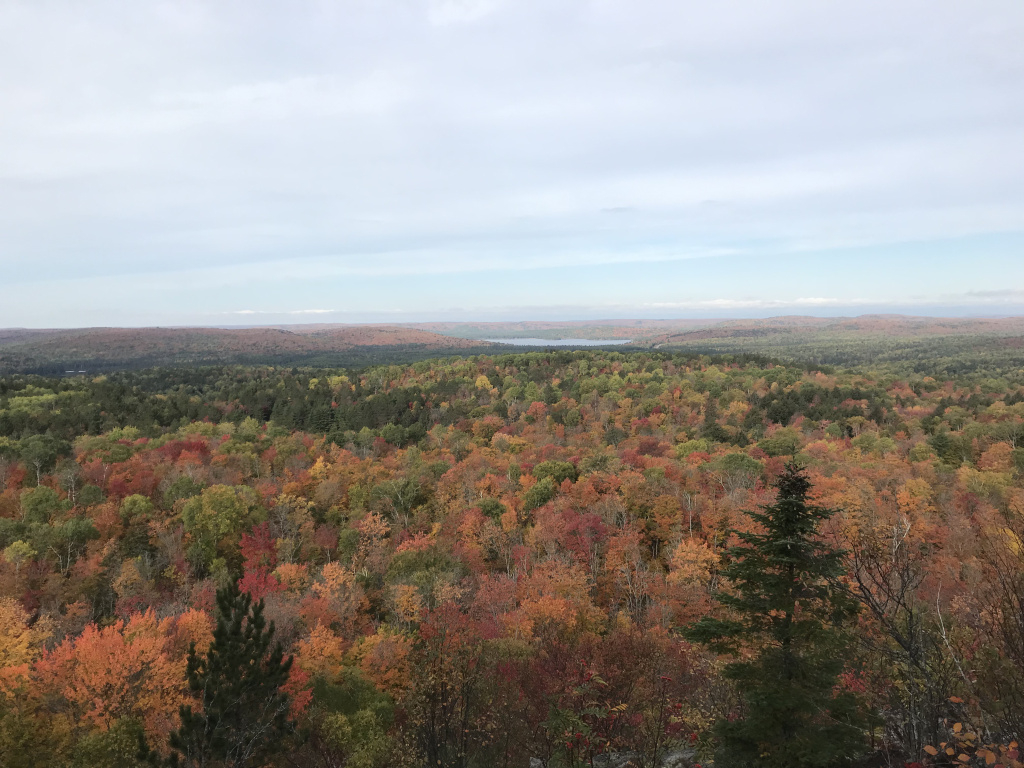
The Cup and Saucer Trail runs along an escarpment in Manitoulin’s northeast corner. The highlights of the trail are a series of overlooks, which take in sweeping views of the whitecap-streaked North Channel, lines of gray granite cliffs, and a forest on the cusp of color. I hiked, I admired, I made a peanut butter sandwich in the parking lot – and moved on.
Rattling back onto the mainland, I turned north toward the mining metropolis of Sudbury. Sudbury has a number of attractions, including two innovative museums. I was interested, however, in only one thing: the Inco Superstack. This 1,250 foot chimney – the tallest in the Western Hemisphere – was built in 1972 to disperse the toxic fumes of nickel smelting, which had killed trees and stained rocks for miles in every direction. It worked, and works, at the price of absolutely dominating the landscape.
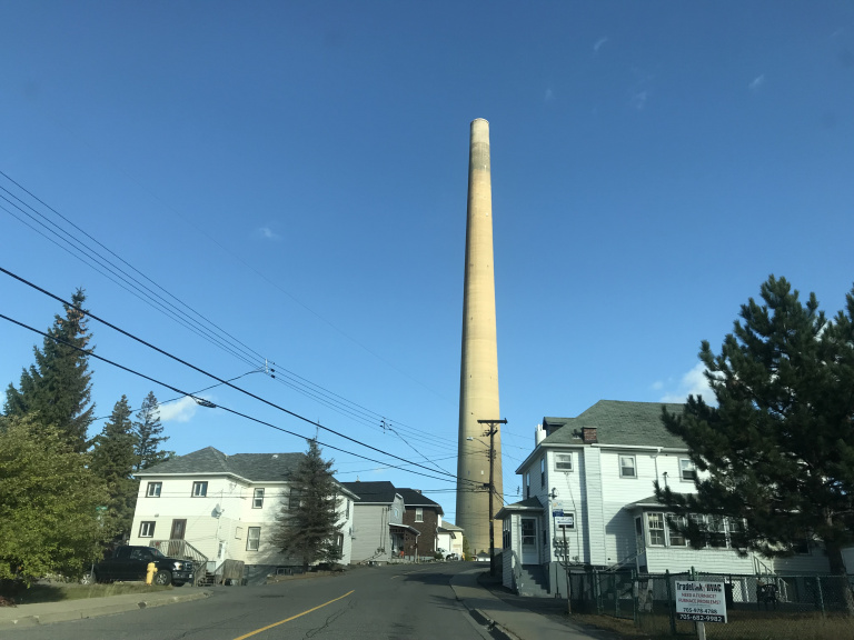
I first caught sight of the superstack when I was more than fifteen miles away, and it grew immensely as I approached. Since the factory grounds were closed to visitors, I drove to the edge of a residential neighborhood a few blocks away, parked, and watched low clouds brush the chimney’s midsection. Then, oddly satisfied, I continued east.
For about two hours, I followed the main highway, driving between endless ranks of pines toward a pale moon. Then my GPS, in its infinite wisdom, decided to route me down a series of remote roads that ducked and wove between reedy marshes and ruddy ridges. It was all very scenic; but I was getting low on gas. Most of the tiny towns I passed through had a bar. A few managed a church. But none, apparently, had the wherewithal to maintain a gas station. Twilight fell; the road twisted on. My phone had no signal. Finally, 70 miles in, I saw a station. Heart leaping, I pulled in – and discovered that it was attendant-only, and closed.
I finally found a working station a few miles down the road, and continued into Algonquin Provincial Park. After at last discovering my campsite (I missed the campground twice in the dark), I set my tent up by lantern light, boiled dinner, and more or less immediately collapsed into my sleeping bag.
10/7
As usual on this trip, I was up before the sun, and had my tent packed away by first light. I was rewarded for my restlessness by being the first in the parking lot for Algonquin’s famous (and famously popular) Centennial Ridges Trail. Before setting out, I strung up a clothesline, hung my damp tent and tarp, and spread my sleeping bag over the hood of my car. Then I was off.
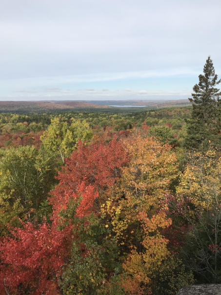
The trail lived up to the hype. Though not especially long – only about seven miles – it was surprisingly rugged, and involved a great deal of scrambling up and skidding down abrupt hills. At three different points, the trail traced a ridgeline overlooking miles of maple-splashed hills and birch-gilded valleys. Between these overlooks, it skirted wilderness ponds and wound beneath rustling branches and drifting leaves.
After five leisurely hours, I returned to the now-crowded parking lot, packed away my more-or-less-dry gear, and enjoyed my customary peanut butter sandwich. Onward, then, past the east edge of Algonquin (blazing maples, passing clouds), through a region of rustling corn and log barns, and into the bustling city of Ottawa.
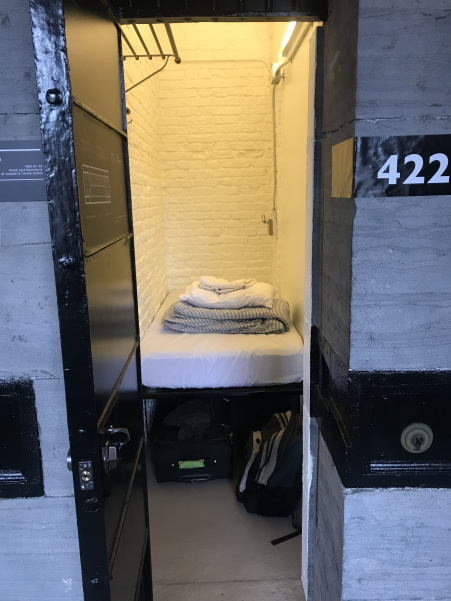
A few weeks before, I had booked a room at the Ottawa Jail Hostel for a price so low that it should have raised my suspicions. When I arrived at the hostel – which, as the name suggests, is built into the city’s mid-nineteenth century jail – I was given my key and shown what $21 had bought me. I had known that I would be staying in a former cell. I had failed to anticipate, however, that that cell would be only three feet wide.
Seeing little reason to linger in my “room,” I set out to explore. The weather – in a pleasant departure from the first week of my trip – was very pleasant, and I strolled around central Ottawa in shirt sleeves, pausing to admire the buildings of the Canadian Parliament (unfortunately closed for renovation).
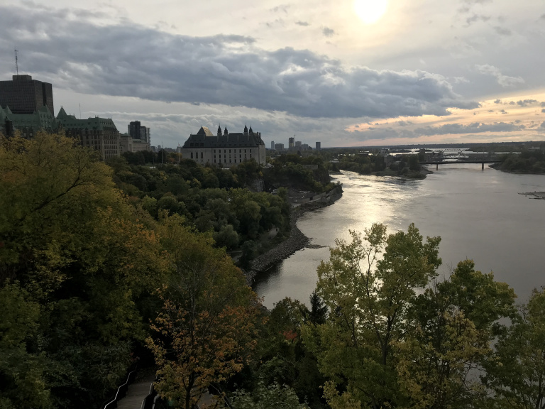
After walking for an hour beside the placid Ottawa River and Rideau Canal, I ate dinner and indulged in a beavertail – a splendidly sugary and savory cousin of the elephant ear. Then, as the sun set, I returned to the common room of my hostel. Such spaces always attract an interesting crowd, and this one was no exception: within a few minutes of my arrival, I found myself involved in a one-sided conversation with a conspiracy theorist who had come to Ottawa for government records that would (as he put it) “destroy Joe Biden.” I nodded politely, and retired to my cell.