Pueblo, Co – Holbrook, AZ
5/17 – 5/20/16
5/17
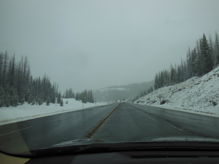
Watching the local news as I ate breakfast this morning, I was dismayed to see snow in the forecast for much of Colorado. The wind outside was bitingly cold, and the sky threatening. Black clouds scudded only a few hundred feet overhead, lapping at the tops of the towering blast furnaces on the edge of town. The ceiling lowered as I drove southwest, finally wrapping the road in fog. I noticed suddenly that the treetops on the surrounding hills were white; a few flakes drifted past my window; and then, as I rounded a corner, wind-driven snow enveloped my car. The squall lasted for about twenty minutes. Then, as swiftly as it had begun, it stopped. The clouds cleared; and the highway descended to a vast plain of winter-dead grass. At a bend in the road, a distant range of snow-capped mountains came into view.
Sighing brown grass lapped at the road leading to Great Sand Dunes National Park. The dunes themselves came into view about ten miles from the highway. The spectacle was arresting – literally, in the sense that I pulled over to admire the view. Against a backdrop of peaks brilliant with fresh snow sprawled a vast tan moonscape of sand, whose summits and valleys mirrored and counterpointed the peaks above.
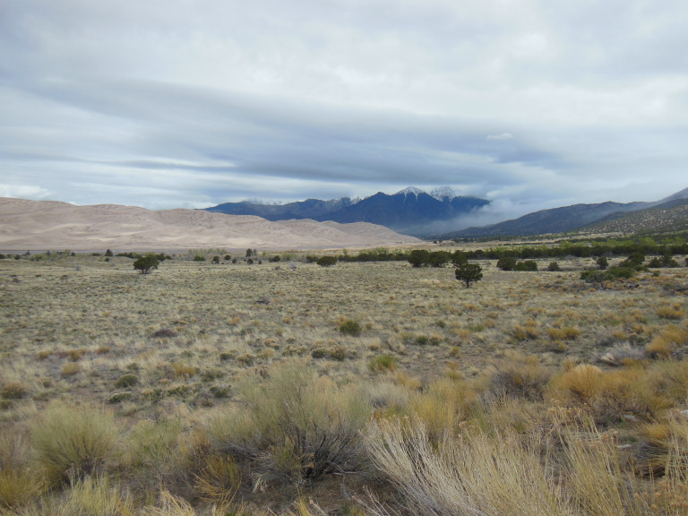
At the visitor center, the door of my car was nearly wrenched from my grasp by the wind. Staggering inside, I asked the ranger about the forecast. He didn’t mince words: “not good.” With temperatures hovering in the mid-forties, a steady 35 Mph wind was blowing, gusting to 60; and thunderstorms were forecast in the afternoon. I had to put my heavy coat over my sweatshirt to explore even the short orientation trail near the visitor center. Shivering, I admired the scale of the dunes, which towered 800 feet above the surrounding landscape. Even from a mile away, I could see sand sheeting off the dune tops in the wind.
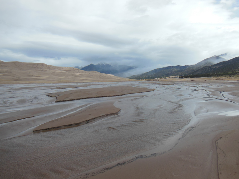
The Great Sand Dunes were formed by the scouring action of a million years of wind. This force was in full swing during my visit. The instant I opened my door in the dune field parking lot, a gust whipped grit into my eyes and open mouth. Blinking and hacking furiously, I made my way toward the dunes. To reach them, I had to ford the braided channels of a broad meltwater creek – an operation that entailed taking off my shoes and hitching up my pant legs, wading through the frigid meltwater, and trudging barefoot along the opposite bank until my feet dried.
Shoes back on, I began the long climb up. My destination was High Dune, an eminence about a mile and a half (as the crow flies) from the parking lot, and some eight hundred feet above. The climb proved much more difficult than I had imagined. Loose sand lay deep over virtually every part the dunes besides the crest. Walking the crest, however, exposed one to the full force of the wind, which howled over the dunes with hysterical intensity. Deafened and half-blinded by the wind, I kept my head down as I climbed, peering through grit-crusted eyelashes at the sand swirling around my feet. The snowy peaks of the Sangre de Christo Mountains, crowned by masses of silver cloud, gradually lifted themselves over the dunes as I ascended. Slope succeeded slip face, ridge rose to ridge; and then, suddenly, I was at the summit.
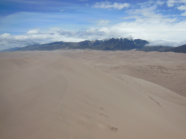
It was an exhilarating moment. Driven by the resistless wind, sand sheeted off the knife edge of the dune, spraying against my back with waves of grit and whirling runnels around my feet. The tan dunes and snowy peaks played off the brown prairie and the dark clouds of an approaching thunderstorm in a riveting show of color and light. Legs braced, skin tingling with static electricity, every sense enveloped in the force and the roar of the wind, I stood for long minutes atop the crest. Seldom have I felt so exposed, or so thrilled.
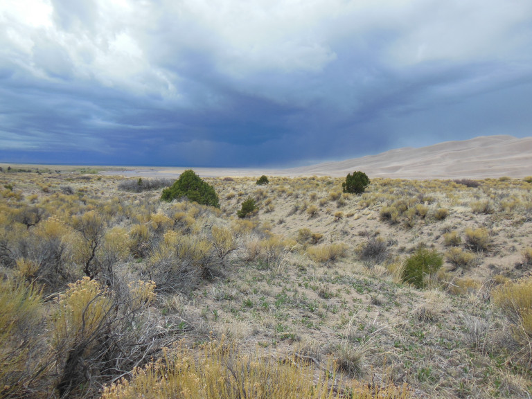
Sandblasted again on the way back down the dune, I splashed my way back across the bitter stream, and then hiked for a few miles along the far bank, drinking in the views of mountain and dune. On the return trip, when I was still about a mile from my car, I noticed a massive bank of clouds gathering to the west. As I watched with growing trepidation, they lowered and grew pitch black, sending long streamers of rain and occasional spears of lightning down to the plain. After snapping a few photos of the dunes, starkly outlined against the storm, I jogged back to my car, reaching it just as the first rain drops began to spatter on the sand.
I drove back to the highway in a torrential downpour, mixed at turns with sleet and hail. As I gained elevation again, the rain turned to a driving snow. As I ate dinner at a surprisingly good Mexican restaurant in South Fork, CO, I watched waves of sleety rain spray a landscape of windswept pines, and was silently thankful that I was not camping that night.
5-18
The temperature was just above freezing when I left South Fork this morning, with snow on the hills and trees just above the town. Following Hwy 160 west, I drove into another snowstorm, this time heavy enough to accumulate slightly on the road. I pulled over at the head of a pass and opened my window. Heavy flakes of snow whirled past on a driving wind, clinging to the heavily-shrouded spruces and varnishing the winter drifts mounded by the roadside. It was hard to believe that it was mid-May.
The highway descended; the snow changed to rain, the spruces to junipers. As I approached the southwest corner of Colorado, the mountains subsided into cliffs of pale sandstone overlooking a scrubby plain. By the time I reached Mesa Verde, I felt myself close to the invisible line separating the mountain from the desert southwest.
After the emptiness of Great Sand Dunes, I was taken aback by the crowds in the Mesa Verde visitor center. Purchasing tickets for the only cliff dwelling tour still available, I began the long drive into the park. The views along the way were striking. From the overlook at Park Point (the highest elevation in the park), a remarkable variety of landscapes was on display. Snowcapped mountains reared up to the east; a long line of reddish cliffs stretched westward; greening prairies rolled north; south, mirrored by a broken ceiling of dark clouds, an infinite tapestry of canyons and mesas stretched to the horizon. This southward prospect, framed by a ghostly forest of fire-killed junipers, fascinated me. I drove eagerly into the heart of the view.
The Mesa Verde museum, though dated, is very informative. It documents the gradual evolution of ancestral Puebloan culture, and the sudden emergence – perhaps in response to security concerns – of the famous cliff dwellings. It was only around the beginning of the thirteenth century, after hundreds of years atop the mesas, that the Puebloans began to construct homes, granaries, and ceremonial centers in sandstone pockets along the canyon; and only a century later that the cliff dwellings were abandoned, for reasons hotly debated by people whose job it is to hotly debate such things. Whatever the cause, it seems clear that the cliff dwellers moved south to Arizona and New Mexico, where their descendants still live.
An short trail behind the museum overlooks Spruce Tree House, a modest-sized cliff dwelling crouched beneath a mighty (and collapsing) arch of sandstone. The dwelling itself is closed on account of safety concerns. I was able, however, to hike the pleasant three mile trail ringing the site, which affords impressive views of the stony canyon and a panel of cryptic Puebloan pictographs.
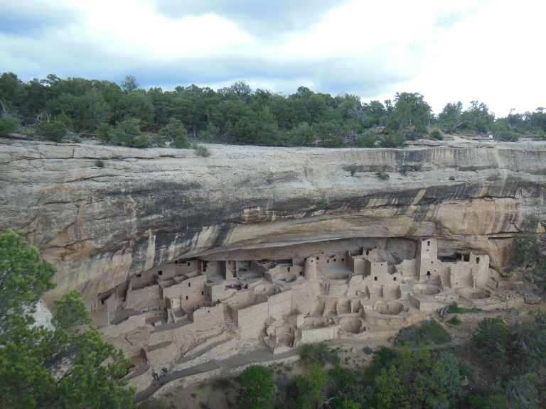
Detained by my hike, I arrived just in time for my scheduled ranger-led tour of Balcony House, a cliff dwelling named for the low porch attached to part of its second story. Getting to and from the site was something of an adventure. Ingress is via a three-story ladder, and egress through a two-foot high tunnel. These acrobatics aside, the tour was engaging and informative, and provided a sense of how complex the web of residential units, granaries, and kivas in even a relatively small cliff dwelling could be.
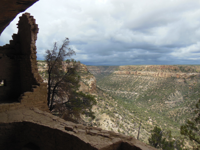
As I prepared to crawl through the Balcony House’s exit tunnel, I noticed the telltale dark clouds of a thunderstorm approaching from the north. The rain started as I was taking pictures of the Cliff Palace – the largest cliff dwelling in Mesa Verde – and freshened to a downpour as I drove along the mesa top road. By the end, I could do little more than park, dash out to the site, take a few rain-spotted photos, and sprint back to the car. This was a pity, as many of the cliff dwellings were architecturally impressive and picturesquely sited. I thought especially evocative a dwelling notched into a sandstone face that was topped by a vast ghost forest of burnt juniper.
As I drove out of the park, I was treated to an expansive view of storm clouds over the sea of mesa. Gray sheets of rain slanted down on the checkerboard landscape, backlit by sun on red hills at the horizon edge.
5-19
This morning, near the New Mexico border, I definitively entered the Desert Southwest. As the highway dove south and lost elevation, the scrubby plain grew browner and sparser; the pale cliffs to the south dissolved into rosy buttes; and the clouds parted to reveal a sky of burnished turquoise.
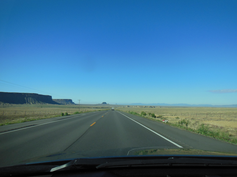
Graffiti-spattered signs announced that I was passing through the reservation of the Southern Ute Tribe. The landscape I passed through was awesomely empty desert, scarred by draws and overseen by isolated buttes. Besides the endless line of pylons beside the road, the only signs of habitation were occasional clusters of mobile homes, ringed by derelict vehicles. Dominating this melancholy landscape was the massive red-black butte known as the Shiprock, which hovered on the horizon for twenty miles.
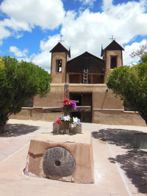
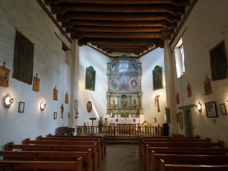
In northern New Mexico, I turned onto state highway 96, a winding mountain road broken every few miles by cattle guards. On both sides of the road, steep hills of pale rock, flecked with crimson, rose like breaking waves. In time, these gave way to crimson hills mantled with juniper, which rolled off toward a distant line of snow-capped peaks. Near the end of my drive, I made a detour to the little Spanish village of Chimayo, high in the hills over Santa Fe. Like virtually all visitors to this remote spot, I was drawn by the village church. The Santuario de Chimayo was built two hundred years ago on the site where a local priest discovered a buried crucifix. It remains an important pilgrimage site for New Mexican Catholics, who take scoops of earth from the hole in which the crucifix was discovered; a chapel dedicated to cures effected by the miraculous soil features a rack of discarded crutches and votive crosses. The church itself is a charming building with the rounded profile of adobe construction. During my visit, the cottonwood trees in the adjacent yard were releasing their wispy seeds, which drifted picturesquely through the sunlight around the bell tower.
After the reflective quiet of Chimayo, I was taken aback by how crowded (and touristy) downtown Santa Fe was. Thanks to a combination of the city’s genuine Spanish colonial roots and a more recent fascination with faux-adobe architecture, Santa Fe feels timeless –a remarkable feat for a major American city. I was most interested in the two most significant relics of the Spanish colonial period: The Palace of the Governors, and the Church of San Miguel. One is reputed to be the oldest public building, the other the oldest church, in America.
I started with the Palace of the Governors, now part of a museum devoted to the history of New Mexico. The first iteration of the building was constructed in 1610; and the site has been occupied ever since –first by the Spanish governors, then by Pueblo rebels, then by Spanish governors again, and finally by American governors of the territory of New Mexico. Each of these occupations has left its mark on the present building, the only surviving portion of what was once an enormous administrative complex.
After walking around the adobe-lined streets of downtown Santa Fe for a bit, I turned to San Miguel. An unassuming adobe structure, the church’s most remarkable feature is its retable (the panel behind the altar), an interesting provincial reflection of the gilded altarpieces of seventeenth-century Spain.
These relics of the colonial era were wonderful; but I did not linger in downtown Santa Fe, for the simple reason that I am not elderly or wealthy enough to see much appeal in shopping. Every other building seemed to be an art gallery, devoted to the same blend of Spanish- or Pueblo-themed jewelry and décor. I half-expected a shifty character in a trench coat to materialize from some dark alley and ask – “hey buddy…wanna buy some authentic Navajo turquoise armbands?”
5-20
Always a sucker for a scenic route, I followed the so-called Turquoise Trail from Santa Fe to Albuquerque, passing a long series of juniper-dotted valleys and half-empty mining towns. I especially like the town of Golden, whose meager adobe church stood picturesquely against a backdrop of blue hills.
Breaking my interstate rule, I hopped onto I-40 in Albuquerque, and raced toward the Arizona border. Instead of hurrying through to Petrified Forest National Park, however, I decided to tour Malpais National Monument, which stood conveniently beside the interstate. Malpais (badlands) is so-called on account of its tormented landscape, a legacy of (geologically) recent volcanic activity. This history was laid out before me from an overlook on the east side of the park. A long line of sandstone pinnacles, legacy of an older landscape, ranged on either side of my vantage point. To the north, the black scar of a recent (c. 3000 yrs. Ago) lava flow snaked across a broad plain. West, a line of igneous cliffs was punctuated by the cinder cones of dormant volcanoes.
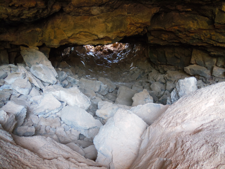
I got a close look at the arrested violence of this landscape in the course of a four mile hike on the other side of the monument. I began by exploring a lava tube. When flowing down a gentle slope, lava flows sometime form long tunnels through volcanic debris. The example I explored was about a half-mile deep. I picked my way over the rubble-strewn floor of a tunnel that twisted – left, right, up and down – through black rock perforated by volcanic gasses. Having only a small flashlight with me, I turned around after a few hundred yards. At one point, on a whim, I turned off the light. Never have I seen – or felt – darkness so profound. I was glad to get back into the sun.
Other relics of ancient eruptions lined the path. Pits and chutes left by collapsing lava tubes punctuated a landscape of scattered juniper and golden dry grass. The path culminated in a cinder cone, a hill of ash a few hundred feet high. Rugged lava flows tormented the landscape along the return trail.
Moving along a two-lane highway about thirty miles south of I-40, I stopped next at El Morro National Monument, better known as Inscription Rock. For more than seven centuries, Pueblo, Spanish, and finally American travelers have carved their names into an isolated sandstone butte, drawn by the only spring of fresh water for miles. I especially liked the inscriptions of the Spanish grandees, who employed courtly language and an elegant script even in this remote setting –presumably to impress the next passing grandee.
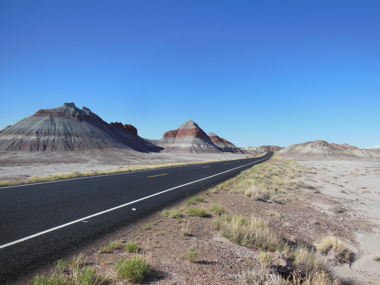
I crossed the border into Arizona, and made my way to the northern unit of the Petrified Forest NP, better known as the Painted Desert. Like so many southwestern landscapes, the Painted Desert is the will, testament, and legacy of erosion. Layers of mudstone, sandstone, and shale, colored by absorbed minerals, have here been exposed in a giddy profusion of cross sections. Even in the glaring light of mid-afternoon, the colors were gorgeously vibrant. I stopped at every pullout, and took dozens of wholly inadequate pictures.
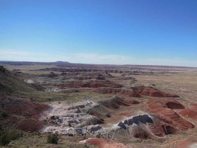
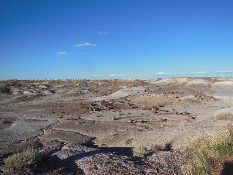
The Petrified Forest proper is really a badland – that is, a zone of loosely-consolidated sedimentary rock, subject to rapid erosion. Like the more famous badlands of South Dakota, the hills of Petrified Forest feature friable rock in a dazzling array of colors, cut into eerie shapes by the action of water and wind.
Badlands often contain fossils. What makes Petrified Forest distinctive is the number of silica-infused logs embedded in the strata. In the Mesozoic, northern Arizona was located near the equator, and featured at least one massive tropical river system. The logs preserved in the Petrified Forest were washed up on the banks of these tropical rivers, buried in silt, and eventually impregnated with silica. Unless polished, admittedly, the logs don’t look like much, though they do sparkle in raking light. More impressive to me was the profusion of the logs, and the way their colors were set off by the underlying strata.
On the way to my hotel in nearby Holbrook, I drove through a landscape transfigured by sunset. To my right, the sun was sinking and dissolving over the erosion-spiderwebbed desert. An endless freight train sparkled in the middle distance, cars silhouetted. To my left, a full moon rose from behind a blood red mesa. The sun sank beneath the horizon just as I pulled onto the main street of Holbrook- which happened to be old 66. The moon orange and gigantic behind me, I cruised one last time down the mother road – before pulling, with a bathetic squeak of my tires, into a rundown Motel 6.