Joliet, IL – Pueblo, CO
5/13 – 5/16/16
It was past time to get away. As I sat at my desk, poring over tedious books and laboring on unpublishable articles, I found my eyes and thoughts drifting, ever more insistently, toward the interstate behind my apartment. Some nights, as I watched semis process through the small hours, trailer lights flitting like torches in the brushy easement, the fantasy came of joining them, of jumping into my car and driving till the gas ran out, losing myself in the lights and hum of a highway somewhere, anywhere far away. And so I resolved to take a road trip. The only question was where.
In retrospect, the answer was obvious. I am a product of the Midwest. With the exception of a semester abroad and a series of protracted research trips in graduate school, my entire life has played out against a more or less unchanging backdrop of flat accents and flatter landscapes. Don’t get me wrong – I like the Midwest. But I found myself, after years of reading and thinking about cities, longing for natural beauty; and the Midwest, for all its various charms, offers rather little in that department. I wanted to see mountains, hike canyons, traverse deserts – and for that, I would have to go west.
Led in turn by fantasy and Frommers, I cobbled together an itinerary. Beginning from my parents’ home just south of Chicago, I would trace a long loop through the mountain west: Illinois to Missouri, Missouri to Kansas, Kansas to Colorado – and so forth, wheeling clockwise through the desert Southwest and Rocky Mountains around to Montana and the Dakotas. I would see most of the western national parks along the way, and tent camp wherever I could. Never one to make small plans, I budgeted seven full weeks for the trip.
I should be clear about my motives for travelling so long and far. I am not trying to escape anything in particular, save perhaps the dull ache of being over-educated and unemployable. Likewise, I have no illusions about self-discovery, for the simple sobering fact that I have lived just long enough to know myself the same prosaic animal inside and out. I am travelling, ultimately, for the simple reason that I can. Jobless, unattached, slightly disgruntled – I will never be as willing and able to drop everything and go.
5-13
On a cool, clear morning, windows open and radio on, I drove out of Joliet. Out, past the weathered houses and brush-filled quarries of Rockdale; out, under the weary banner of smoke steaming from the power plant on the Des Plaines; out, through the last ragged edge of suburbia, and into the fields beyond. A few miles south, I turned onto old Route 66, the highway I planned to follow to St. Louis. Interstate 55, which parallels the old mother road, would of course have been much faster; but like all interstates, 55 traverses the landscape without being part of it. I wanted to maintain the human scale, to see the greening fields and little towns along the way.
This wish was abundantly gratified. As I passed through a long series of more or less prepossessing country hamlets, I ruminated about local history. Illinois country towns, laid out in the same era by similar groups of settlers, are of a piece. In each, a neat checkerboard of streets, oriented to the grid of townships and sections that spans the Midwest, is stiffened by a row or two of fading commercial buildings, dominated by the twin spires of church and grain elevator, and populated by a goodly crop of frame and foursquare houses. Although this lack of variety does not make for very exciting roadside scenery, it provides a sense that each town is every town – an artifact of the great push that settled the Midwest and plains in the nineteenth century. It seems appropriate that Route 66, a latter-day trail to the Pacific, should connect these relics of an older westering impulse.
“Relics” is a fitting title for many of the towns along 66. In tandem with the general decline of American agriculture, most are shrinking. A sad number are clearly dying, or are already all but ghost towns. Even those that seem reasonably vibrant have a curiously anachronistic air. When I stopped in Lincoln, a pleasant town a little just north of Springfield, the busy square surrounding the county courthouse, with its bustling specialty shops and neatly maintained lawns, seemed to have frozen in about 1960. I could’ve sworn that man walking in front of my car tipped a fedora in greeting as he passed.
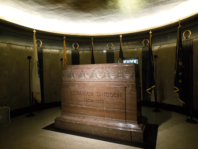
Thanks to its status as state capital, Springfield felt a little more cosmopolitan than the towns on 66, but only a little. The most remarkable parts of town are of course those sites associated with Lincoln, who lived and practiced as a lawyer there for a quarter-century. Having not been there since grade school, I stopped first at Lincoln’s tomb, about the closest thing Illinois has to a pilgrimage site. The impressive effect of the obelisk-topped monument and the echoing tomb chambers was somewhat compromised by hordes of field-tripping (and clearly very bored) children.
The Lincoln library and museum, well-presented new facilities, were also awash in kids. It is not coincidental that the Old State Capitol and Lincoln House, free of grade schoolers, were my favorite sights in town. I was particularly impressed by the Lincoln house, and especially by Lincoln’s bedroom, which still contains the desk he used to work up his court cases and compose speeches. No other place I know allows such immediate contact with Illinois’ most famous resident. After leaving the Lincoln house, I strolled briefly around the city center, pausing to admire the baroque extravagance of the “new” capitol building. Maybe the state had money then.
I picked up 66 again outside Springfield, passing through another series of little towns. My last stop was the village of Mount Olive, where I saw the grave of Mother Jones, the famous labor organizer who ended a very active retirement by dying here at age 100 while trying to rally local coal miners.
5-14
I spent the night with relatives in Belleville, an Illinois suburb of St. Louis. I woke to discover that yesterday’s placid weather was gone, swept away in the night by a cold front that had knocked the temperature down into the low forties and kicked up a strong north wind. Such are the pleasures of a Midwestern spring.
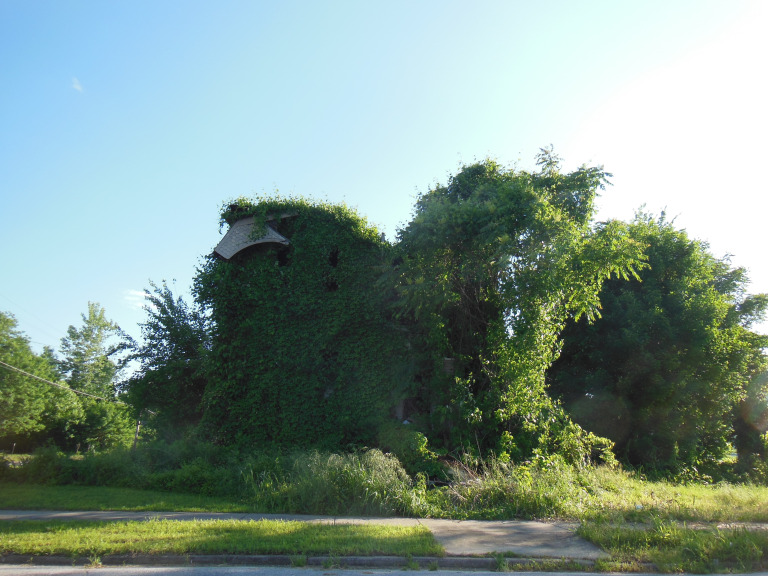
I began the morning by indulging an old habit. In East St. Louis, on the Illinois side of the river, stand the remnants of what was once one of the largest stockyard and packing districts in the country. I had read online that the Armour packing plant, a massive complex built at the turn of the twentieth century, was being demolished to make room for a new industrial park. When new, the plant was regarded as an industrial marvel, widely admired for its modern machinery and integrated production lines. With the general decentralization of the packing industry, however, it was abandoned more than fifty years ago, and has stood empty since, becoming something of a mecca for urban explorers. About half the plant was already down when I pulled up. The jungle-like overgrowth had been cleared, and the five-story packing building stood alone in a plain of shattered red brick and warped machinery. I saw a way in through a collapsed elevator shaft, but played it safe – and legal – restricting myself to photos of the exterior.
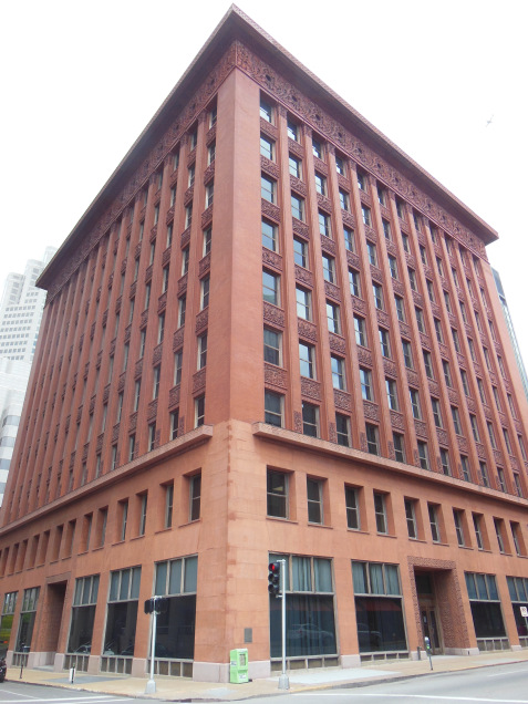
I crossed the river into downtown St. Louis, parked in a convenient garage, and set out to explore the city’s remarkable collection of late nineteenth and early twentieth century buildings. Although my affinity for prewar skyscrapers probably has something to do with my background in the classics, it is also a matter of taste: the glass boxes of modern architecture may be a more logical solution to the problem of height, but they are not – to my eye – an especially interesting one. I spent the morning walking the windswept streets of downtown, pausing to photograph some of the more interesting buildings. The highlight was Louis Sullivan’s Wainwright Building, one of the great architect’s most elegant skyscrapers. Sullivan famously modeled his tall buildings on the classical orders – like a column, they have a firmly molded base, a “shaft” with strongly emphasized vertical accents, and a richly ornamented “capital” (cornice). The Wainwright Building epitomizes this model, rising to a gorgeous terracotta garland of figured vines. Other downtown highlights included the Civil Courts Building – modeled after the ancient Mausoleum of Halicarnassus – and the Southwestern Bell Building, an art deco skyscraper with a ziggurat-like crown of setbacks.
Skipping the Gateway Arch – I was up there years ago, and didn’t much care for the claustrophobic little pods that bring you to the top – I drove west to see the Cathedral Basilica. I happened to arrive just before the diocesan confirmation ceremony, and had to squeeze through a crowd of gawky adolescents and milling families (“hold STILL, Johnny – I’m trying to take a picture!”) to get a good look at the spectacular gold mosaics of the nave and cupola. Few other places in this country have such grandeur.
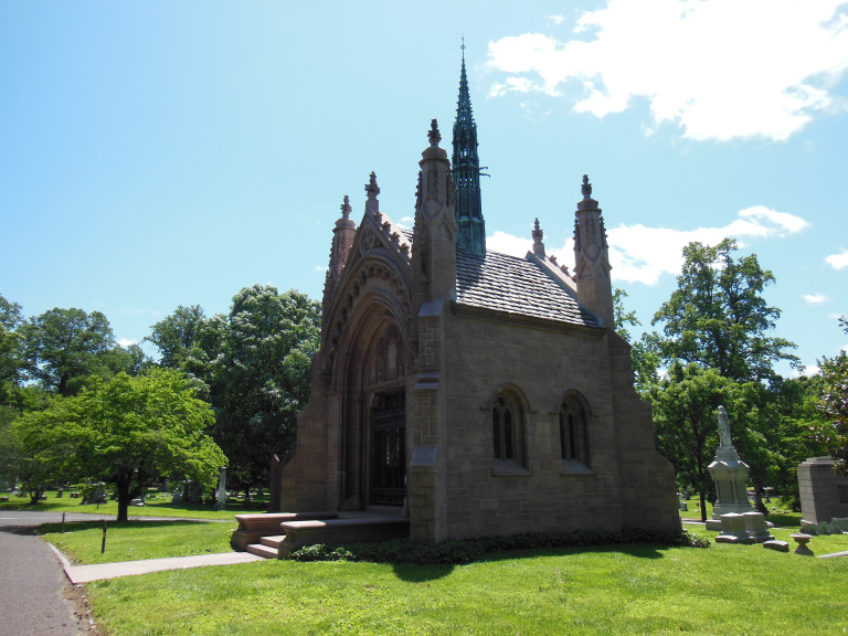
Ducking back through the crowd, I drove out to the immense Bellefontaine Cemetery. I have always liked old cemeteries – not, I hope, from any particular morbidity, but because they allow an unparalleled glimpse into a community’s history. Like many cemeteries laid out in the mid-nineteenth century, Bellefontaine is artfully landscaped. Gravel lanes wind among groves of oaks and sloping lawns, creating a distinctly parklike atmosphere. I drove slowly along these paths, stopping at the graves of famous men – such as William Clark of Lewis and Clark fame – and at such architectural gems as a mausoleum modelled after a Gothic chapel, complete with tiny bronze spires and gargoyles.
Leaving St. Louis in mid-afternoon, several hours later than I had intended, I began to follow the Mississippi south. At first, I drove on the Missouri side, chiefly to get a good look at the old French town of Ste. Genevieve, which retains a number of colonial-era wooden houses. My chief destination along this part of the river, however, was Kaskaskia, a tiny hamlet located in the only patch of Illinois west of the Mississippi. This enclave was properly east of the river until the channel shifted during a cataclysmic nineteenth-century flood. Rather than resurvey things or shift the post office, officials on both sides of the border allowed the waterlogged remnants of the town to stay in Illinois by courtesy.
The drive to Kaskaskia was memorable in itself. Rolling over a series of flood channels (where I passed two boys trying, with more enthusiasm than forethought, to bowfish from a bridge), I drove an old 1 ½ lane road beside a levee golden with spring flowers. The road mounted the levee, and then descended into the flat Mississippi floodplain. Soon the hamlet of Kaskaskia itself hove into view. The oldest city in Illinois, and its first capital, Kaskaskia was a flourishing trading post when Chicago was still a clutch of cabins in a lakeside marsh. It was here that George Rogers Clark captured an important British garrison in 1778, securing much of the old northwest for the American revolutionaries. The sole memento of this event is located on Kaskaskia’s main street beside a Catholic church, two frame houses, and literally nothing else. In a small shelter built by the park service a generation or two ago, a cranky electric door swings open to reveal the so-called Liberty Bell of the West – a church bell rung to commemorate Clark’s victory. Besides the building housing this relic and the adjacent structures, Kaskaskia consists of perhaps a dozen houses on a mostly empty grid of muddy streets. The town seemed to be recovering from a spring flood: sandbags were heaped in the front yards of several houses, and the air was heavy with the smell of silt.
Crossing back into Illinois at Chester (hometown of the man who created Popeye), I turned onto IL-3, the two-lane highway that follows the Mississippi down to Cairo. The road traced the edge of the floodplain for most of its route. To the left rose the heavily forested bluffs of the Shawnee National Forest. On the right, fields of young corn swept away to the infinite green line of the levee. Occasionally, the road passed down the shuttered main street of some sleepy town, but I saw few cars, and no people, in any of these hamlets. I stopped in Thebes, about thirty miles north of Cairo, to take a quick look at the river. Swollen and brown with the recent rains, the Mississippi was just short of flood stage, lapping at the yards of a few houses near the bank. As I watched an endless freight train cross the river on a nearby trestle, I suddenly realized that it was already evening, and that I had hundreds of miles to go. I hopped back in the car for the last leg of Illinois.
Cairo, the southernmost town in Illinois, is located at the confluence of the Ohio and the Mississippi. This strategic location has always been a mixed blessing. In the days of heavy steamboat trade, it made Cairo a flourishing river port. Every spring, however, it exposed the town to the floods of two great rivers. Over the past century, the Army corps of engineers has ringed the town with earth and concrete levees more than thirty feet high. The road into town passes beneath an immense iron portcullis; in times of flood, this gate clamps down, and Cairo becomes a sunken island amid the floodwaters.
Cairo itself is a melancholy place. Once a wealthy town of nearly 20,000 people, it is now a desperately poor village of 2000, ringed by the ruins of better times. There are a few mementos of the glory days of the nineteenth century, notably the fine Italianate courthouse and custom house. A handful of the town’s many Victorian mansions are well maintained. But most of Cairo reminded me of Detroit’s more blasted neighborhoods. Grain elevators, a hospital, a theater, dozens of stores, and scores of houses all stand empty and decaying. Along one street, two storefronts have actually collapsed onto the sidewalk. Many of these ruins have been swallowed by kudzu, the aggressive Asian groundcover that has taken huge swaths of the southern US in its many-fingered embrace. There was something evocative about the patter of kudzu leaves fluttering over the faces of Cairo’s ruined mansions. I drove out of town in a pensive mood, rattling over ancient brick streets.
I crossed back into Missouri about an hour before sunset. I had planned to do a little hiking in the Ozarks, but had dawdled too long on the way. Consequently, I had before me an uninterrupted drive of nearly five hours. The prospect was not enticing. Growing tired of my book on tape, I began to tune through the AM channels for some local color. The first station I found featured a thirty-second commercial for bowfishing equipment and a series of rants against the government’s agricultural policies. The second was plugging an movie about the government’s plans to “take our guns and our freedom!” The third aired a sixty-year old episode of the Twilight Zone (I’m not a man, Mary…I’m a machine!”), which I listened to with such avidity that I contrived to miss a turn and end up in Arkansas. Finally, all channels faded to static. My world contracted to the faintly glowing dashboard, to the endless sprinting line of the median, and to a firm resolution to never drive across Missouri at night again.
5-15
I left my hotel early, and hopped back on 66 in the southwest corner of Missouri. Though most of the old road has been swallowed by a state highway, short sections – too narrow or twisting for efficient driving – have been preserved as bypasses. I especially liked a segment some thirty miles west of Springfield, which featured an eighty-year old steel bridge and a vintage gas station amid a thick patch of second growth forest.
As I drove, I occupied myself by tuning in to the best Sunday morning programming this corner of the Bible belt could muster. Poor radio reception added to the experience: “and the Loooord said to David…” (static) “give HIM your sins!…” (static) “mend your ways!…” (static) “sinner!” (static) “sinner!” And so on. Thus entertained, I rolled into the pleasant town of Carthage, MO. I stopped on whim when I caught sight of the handsome county courthouse. I have always liked these buildings. Carthage’s example, a Richardson Romanesque fantasy with corner turrets and a clock tower, seemed to epitomize both the blustery rhetoric and the solid civic pride that animated nineteenth-century town planning. The town itself – rather like Lincoln, IL – was well-preserved enough to seem anachronistic. I spent a pleasant half-hour walking through the streets and parks.
Two and a half hours up a modern interstate rushed me into the Kansas City metro. Ever since reading David McCollough’s biography years ago, I have wanted to see the Truman Presidential Library in Independence. This was the first of the presidential libraries, and perhaps the most personal; Truman lived a few blocks away, and maintained an office in the building until his death. I especially liked the reproduction of the Oval Office, furnished as it was during Truman’s tenure and introduced by a voice recording from Truman himself.
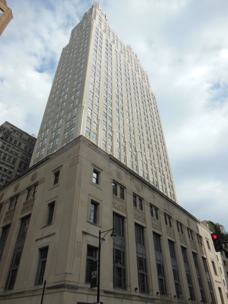
After finishing the museum and driving out to see Truman’s house, I drove over to Kansas City. As at St. Louis, I was chiefly interested in the city’s prewar architecture. Thanks largely to the fact that its machine politicians kept skyscraper construction going through the Great Depression, Kansas City has an exceptionally fine collection of Art Deco buildings. After surveying the downtown from the Liberty Memorial – an impressive Egyptian-themed monument built to commemorate American casualties in the First World War – I drove into the center and wandered around for a few hours. For me, the appeal of Art Deco skyscrapers lies in their massing – that is, in how their volume is sculpted and height accented. Kansas City’s Power and Light Building, City Hall, and Fidelity National Bank (to name only three of the best examples) all exhibit the artfully stepped profile and stylized pinnacles characteristic of Art Deco design.
Hungry after an afternoon of peering at skyscrapers, I drove to a faded neighborhood on the outskirts of downtown to visit Arthur Bryant’s, probably the best-known barbeque joint in Kansas City. The line was building by the time I arrived (a Royals game had just ended), but the men at the counter dispensed pork, beef, and rivers of sauce with practiced efficiency. I opted for the barbeque beef sandwich – which proved to consist of a small mountain of thin-cut beef, four slices of white bread, and a huge heap of fries. The meal was messy but delicious.
5-16
It rained all day. From Kansas City to Pueblo, from central time to mountain, from Great Plains to High Plains – rain. Sometimes a mist, sometimes a downpour; mixed with hail, shot through with sun, lashed by winds; susurrating, streaming, pounding – rain. With the uniform landscape and changeless ceiling of low scudding clouds, the patter of raindrops and the scrape of my overworked wipers lent a numbing monotony to today’s drive.
The Flint Hills of western Kansas are often described as the most scenic portion of the state. Since we’re talking about Kansas here, that might not be saying much – but I had looked forward to seeing a picturesque stretch of virgin prairie. For all I know, they were scenic – the rain was so heavy that I could only see the merest suggestion of green slopes. The clouds were low enough to scrape even these modest hilltops; at one point, I passed a windmill array visible only as a long rank of column-like bases and blade tips swooping briefly under the mist. I had planned to take a brief hike near Manhattan, KS – but discovered that the trail was closed (appropriately enough) on account of a washed-out bridge.
To dispel my gloom, I ate lunch at the Cozy Inn, a well-known burger joint in Salina. Occupying one of the four stools at the counter, I ordered four of their famous sliders, which I devoured while watching the local news on the small TV perched in a corner. The forecast was for more rain.
I turned south at Salina, merging onto US-50, the two-lane highway that would carry me all the way to Pueblo. With the exception of an occasional semi trailing streamers of spray, I had the road more or less to myself. The landscape gradually flattened and lost all color but the mottled green and brown of a shortgrass prairie in spring. Endless lines of telephone poles and fence posts lost themselves in the gray distance. Oil jacks, bobbing in ragged unison, lent rhythm but no relief to the scenery. Every ten or fifteen miles, a massive grain elevator would loom through the mist like a medieval keep. A few minutes later, the little town huddled below would become visible. A few dozen empty-looking buildings would flash by, and then the prairie would resume.
US-50 follows the route of the Santa Fe Trail. In western Kansas, it runs just beneath Pawnee Rock, an important landmark on the old trail. Pawnee Rock was a large outcropping that rose more than a hundred feet above the prairie. A veritable mountain by Kansas standards, the rock was utilized as a lookout post by passing wagon trains. Pioneers enthused about the view from the top –which, frankly, cannot have been too different from the view at the bottom, since there was nothing but prairie for a couple hundred miles in every direction. Reduced to about half its original height by later quarrying, the rock remains, for want of competition, the point of greatest topographic interest in the immediate vicinity, and has accordingly been deemed worthy of a small viewing platform. Turning off the highway, I drove through the mournful little town of Pawnee Rock, where a crumbling elevator hovers over long and unpaved streets of abandoned houses. Atop the rock itself, I stepped out into the drizzly mist to survey the view. A few semis, fog lights on, rumbled along US 50. A grove of oaks, new leaves listless, screened the empty streets of Pawnee Rock. And in every direction, rain fell on silent, sodden, gray-green prairie.
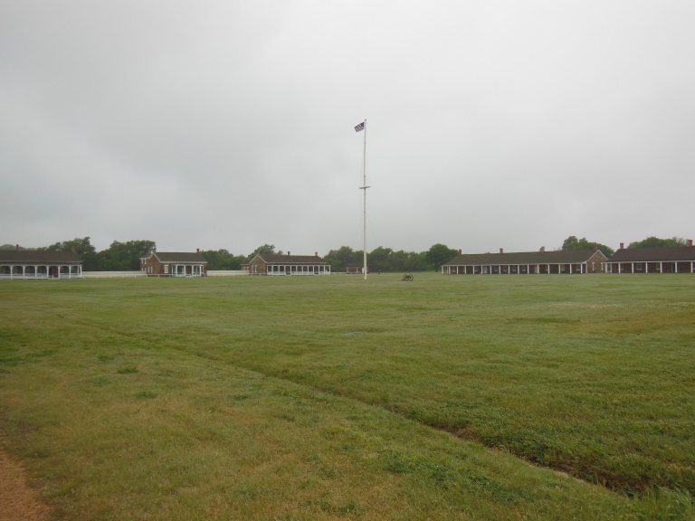
A few miles down the road, I braved the rain again to visit Fort Larned, an army base established to guard traffic (above all, the US mail) passing along the Santa Fe trail. The park service has restored the barracks, commissary, and other buildings to their appearance in the early 1870s, when they housed some 300 infantry and a handful of cavalry troops. All this and more I learned from a very informative and very bored ranger. He directed me to the small but informative museum, where I picked up a brochure for a self-guided tour. I was genuinely impressed with the completeness of the picture the various buildings presented of garrison life on the prairie immediately after the Civil War. I cannot fathom how dull it must have been for the enlisted men here, a hundred miles from the nearest town of any size.
About ten miles from Fort Larned, at the end of a puddle-spangled series of gravel roads, I stepped out into the drizzle to view a small section of virgin prairie, where the ruts of the Santa Fe trail can still be seen. As I walked toward the ruts, trying to avoid the myriad holes of a large prairie dog village, the clouds parted for a moment, allowing shafts of sunlight to jewel the green wheat fields. For an instant, Kansas was beautiful. And then, of course, a dark bank of clouds rolled in, and the rain returned with redoubled intensity. Legs soaked by the dripping grass, I mounted a small viewing platform to see the ruts. After a century of weathering, the parallel ruts of the trail had merged into a broad trench, perhaps twenty feet across and three or four deep. From a small pond that had formed along one of the edges of this depression, a chorus of young frogs chirped – sounding, I fancied, a little like ungreased wagon wheels.
It was now late afternoon. Returning to US 50, I passed Kinglsey (a town that prides itself on being located exactly halfway between New York and San Francisco) and a handful of depressed little hamlets before rolling into Dodge City. All of the touristy Wild West attractions were already closed – which, frankly, was fine with me. I was more interested in the stockyards. Western Kansas is one of the nation’s major beef-producing regions; and the railway corridors of Dodge City, the region’s largest center, feature a correspondingly dense array of feedlots, stockyards, and slaughterhouses. I pulled into a gravel lot near one of the largest stockyards, and walked along the fence for a closer look at the logistics of beef. Thousands of cows, penned by size and breed, stretched through the rain toward the distant lights of a grain elevator. The cattle, feeding from a pen-side trough, startled back as I walked by. “It’s not me you should be worried about, doggies” I thought. On cue, a pickup driven by a man in a cowboy hat pulled up, and asked me not to take any more pictures – apparently, they have problems with animal activists. I assured him that I liked steak too much to jeopardize his business.
After Dodge City, Kansas continued. A few changes were noticeable: the grass by the roadside was sparser and browner, the towns farther apart. The same landscape, and the same tedium, marked eastern Colorado. To allay the tedium, I turned on the AM Radio. One of the first commercials I heard reminded me that I was in Colorado: “…and remember, don’t smoke Marijuana and drive.” Twilight bled slowly into night over the infinite prairie. I trained my eyes on the roadside telephone poles, the sole punctuating marks in a landscape of vast horizontals. Soon these too faded.
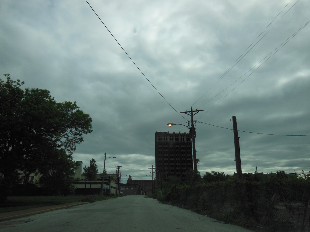
It seemed to take a very long time to get dark. I wondered idly whether my car, moving west at 80 Mph, was skimming the edge of advancing night. When full darkness finally overtook me, I found myself searching for lights. Every five or ten minutes, an eastbound truck would roar by, trailer ablaze with reflective strips. Otherwise, I had no company but the distant pinprick of ranch lights scattered over the prairie. Finally, just before midnight, I rounded a bend and came into view of Pueblo’s massive steel mills, backlit smokestacks steaming in the rain. Heavy industry never looked so good.